Some people may have noticed that there are 10m contourlines as separate maps on the download pages since about 4 weeks. During the process of generating them I noticed quite a few problems in steep areas that should not have been there. So began a long process of improving the contourlines. The problem was that the filters the map compiler runs against any lines were not suited to contourlines. With the help of others mkgmap is now improved a lot in this regard - and kinda resulting from this also normal maps have improved a lot when zoomed out (thanks to Gerd on his never ending improvements to mkgmap). When zooming out - the further you zoom out now - the bigger the improvement.
For all countries and continent maps - except Asia full continent map (will come in 1-2 months - it is a huge work to create them) there are now 20m equidistance contourlines - and 10m equidistance contourlines. On all maps updated from 30. May 2021 you can select 10m or 20m contourlines. The 10m contourliens are now also integrated into the installer. For Mac OSx they are integrated too - and while for windows users the 10m contourlines have to be downloaded separately, for OSx most countries already bundle them in the gmapi Installer. I had planned to integrate the 10m contourlines on 9 April 2021 for the 12 year anniversary of the OpenMTBMap website - but that work turned out to be way way bigger than anticipated - it is easy to create 2-3 maps, but creating 180 different countries/regions means everything is way more complicated and more bugs have a chance to appear somewhere in the process.
Less visible updates however also important. I have reworked the whole relations (MTB routes, Bicycle Routes, Hiking Routes) integration. Before it was kinda random if several routes were using the same way - which name was given to the way. Now this is ordered from most important to least important routes. This previously had also caused problems that if say a regional route and a national route shared the same way - and the regional route was handled before the national - when zooming out the national route was not shown. This is now fixed.
Complete overhaul of the windows installers - I spent about 80 hours optimizing the installer to be faster (yes still a bit slow - as they use lzma instead of lzma2 and do not support multithreaded unpacking of data) and correctly integrate the 10m and 20m contourlines. Also hope they are easier to understand now. There is still some work to be done - concerning if you install separate contourlines only map on both VeloMap and OpenMTBMap installer (with contourlines as separate download) - I will integrate a warning for this in the future. It is now also possible to only install a separate contourlines only map without installing the map itself but obviously I do not recommend this. Updating the installers I have often thought about just moving the windows maps to gmapi format - because I then would not need to fuss around with NSIS installers - but there are so many cool things that can be done with NSIS installers, plus the fact the windows format is IMHO still better than the gmapi format (except the windows registry) - that I recommend windows users to stick on using the classic map format.
Old Contourlines based on Lidar Data:
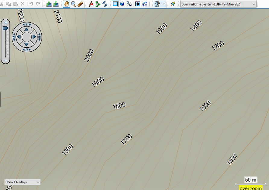
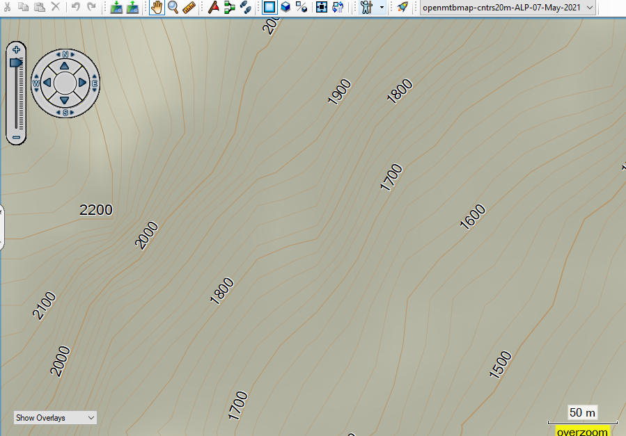
vs the new 20m contourlines - based on the same data but with improved douglas peucker filtering. Notice how the lines are much better aligned to each other. there is no more one contourline crossing another because they were simplified at different locations. This effect will be everywhere - but because the actual distance difference is low - it will only be really visible in very steep areas like on this region. It is a little bit more exact now - but the main difference is that the rounding to the Garmin GPS device is more coordinated.
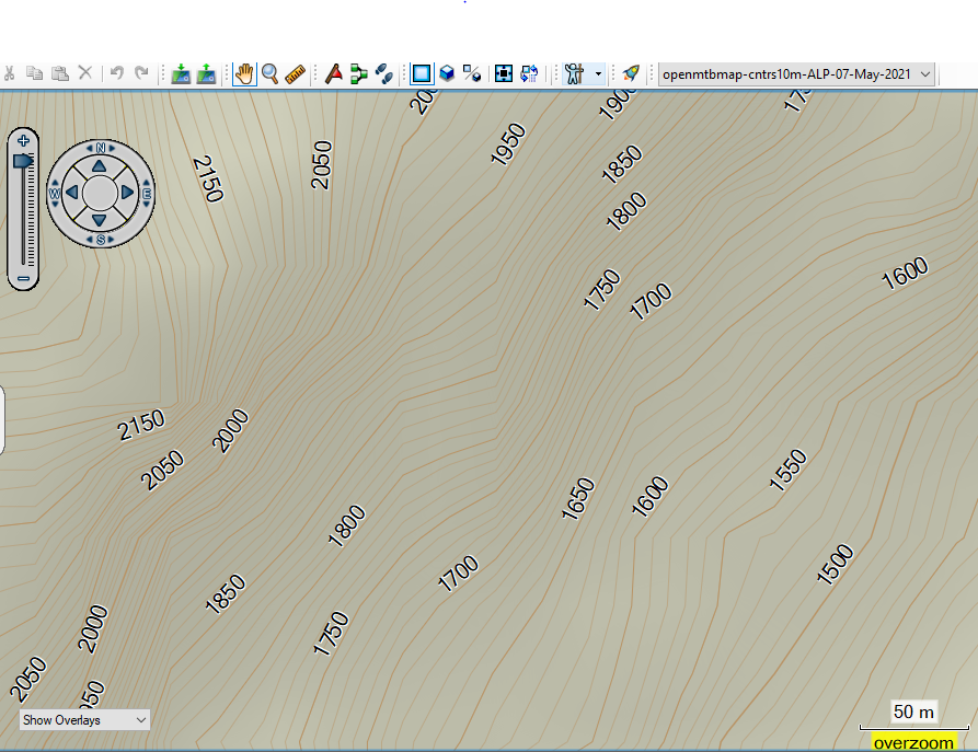
vs the new contourlines at 10m equidistance (and resolution 24 instead of 23 to be even more exact - one point is exact to around 2.8m at resolution 24 vs 5.4m at resolution 23 - this uses a lot more data however. I recommend to use 10m contourlines in hilly or flat areas - and 20m in real mountains like the Alps.
As the maps are updated over the next 24 hours - there will still be slight discrepancies and installers of maps with separate contourlines do not match the map. For OpenMTBMap this should happen much less often than for VeloMap maps (only for english language openmtbmap maps with separate contourlines). From Tuesday 01. June this should all be fixed. I will also still add some more gmapsupp.img contourline maps for continents or huge countries which are right now not online yet. As I need to create them manually with MapInstall this will still take a week or so. For Asia continent contourlines gmapsupp.img map is not possible - as it breaks the 4048 tiles limit. The windows 10m and 20m Asia contourlines map will still come in 2-3 weeks or so - there was a mistake on the first try an my server needs over 2 weeks computing nonstop to create them.
If there are no problems that I overlooked - I will update the Europe map in 4-5 days. The contourlines are ready for the Europe map - but I want to wait to see if I maybe missed some bug related to the installer that I simply did not notice. Creating the Europe map is always quite an effort - over 40 hours of compile time (due to 8 versions - 4x openmtbmap, 4x velomap).
Upcoming Improvements over the next few weeks: I started working on the zoom levels - but stopped this to focus on getting the contourlines updated. I will soon pick this up again and plan to move most ways/trails one zoom level down. Openstreetmap is more and more detailled and I feel it is needed to adapt this. I would prefer doing this only for Europa but I cannot maintain two styles differing in this regard at the same time. Most of my users use the maps in Europe and here it is simply better to have some features appearing later. I already overworked the details when zoomed out further - and think there was a big improvement. The main problem is rivers - I spent hours trying to work around the inconsistencies in river mapping in OSM and making sure important rivers show in lower zoom levels. However the problem being here is that rivers are more and more mapped with relations - and many of those super relations for rivers like the Danube or other major rivers are broken or partly missing. It is better now than 2-3 months ago in my maps - but not perfect. Essentially it would be best to move away from OSM to another more consistent data source for the very far zoomed out regions - but I do not know how to do - nor which data source would be compatible.
Also I am working on a new layout - for people who prefer more of a classic hiking map look. I hope to finish it in 4-5 weeks. I still need some time testing it out in practice on my Edge, Oregon and etrex devices. I still feel there needs to be some adaptions for better contrast - typical paper maps are simply different. However I aim to make it easy to understand for people just used to topographic paper maps. My opinion is still that the color layout I am using right now is way better than the classic maps in readability and possibility to transmit information. All other OSM based maps contain way less information about the quality / usability of ways. But some people are just overwhelmed by it - so I will create that layout for them.
Unrelated to this - I have overworked both OpenMTBMap and VeloMap websites - and included many tutorial videos. Many things were a bit outdated and I tried to correct most of them. Having so much content also means it takes a lot of time to keep it up to date. Most video tutorials are aimed at beginners - however the route planning videos for example may still contain a few tips and tricks also for regular users. I still feel that written tutorials are better than video tutorials - but because some people prefer seeing video tutorials I created video tutorials for nearly all common desktop related tasks with the OpenMTBMaps and VeloMaps. Somewhere on my roadmap are also videos using GPS devices - but they are more complicated to produce so still need some time. I will also still create a video comparing the different layouts and explaining a bit more about them. However that will have to wait until I have finished the classic topographic layout.
Personally I spent the last 6 months in Taiwan improving my Chinese and just came back 10 days ago to Europe. I plan to go to Taiwan next winter again - but lets see about coronavirus situation there (was the safest country in the world until 3 weeks ago - and while I am not afraid of catching the virus - also due to vaccination - I do not like lockdowns so will only go back if there is no risk of lockdowns anymore. I really hope the coronavirus related problems are over for Europe. This has also cost me many donators but luckily there are still enough people donating to OpenMTBMap or VeloMap to allow me to continue. I will soon for the first time since 2014 I think, increase the prices a bit. People using subscription will not be affected.

Hallo extremecarver,
in deiner Info zum großen Update vom 30.5.2021 hast du ein neues (dem klassischen Wanderkarten-Look nahekommendes) Layout angekündigt.
Meist nutze ich die Karten als Wanderer / Fußgänger und Radfahrer. Letzteres zwar mit dem MTB, aber wenn die Wege zu schmal, steil oder steinig sind, ist Schieben für mich keine Schande und ob es bergauf oder bergab geht, erkenne ich an den Höhenlinien (und das nun sogar im super 10m-Raster bei Bedarf). Ich benötige also viel weniger detaillierte Weginfos als die sportlichen Hardcore-MTBiker. Fahrstraße, Asphalt, gut fahrbar, fahrbar und durchkommen aber schieben reicht eigentlich völlig aus.
In der Tat bevorzuge ich outdoor auf dem Oregon zumeist meine inzwischen etwas älteren Garmin TOPO-Karten.
Dort habe ich eine für mich klare und vertraute Farbgebung: blau ist Wasser, braune Linien sind Höhenlinien und vor allem rot bleibt für eigene Tracks, die dann auch während der Fahrt auf dem Oregon-Bildschirm deutlich und schnell erkennbar sind.
Die OpenMTBMaps nutze ich sehr gerne, aber leider meist nur zur Planung am PC mit Basecamp, für draußen ist mir die Wegedarstellung einfach zu überladen.
Nachdem die sportlichen Mountainbiker mit den bisher verfügbaren Layouts sicher sehr gut bedient sind, hoffe ich seit deiner Ankündigung, dass das neue Layout eher meiner Nutzergruppe entgegenkommt (d.h. den Garmin-TOPOs möglichst nahekommt). Also warte ich nun sehnsüchtig darauf.
Kannst du inzwischen schon absehen, wann dieses Layout verfügbar sein wird?
Gruß Sigi
Kommt in spätestens 3-4 Tagen. In der VeloMap ist es schon aktiv (easy Layout). Easy = Wege mit mtb:scale noch in grün. Hike Layout = ohne MTB Schwierigkeiten – aber MTB und Fahrradrouten werden noch angezeigt. Für eigene Tracks habe ich Pink reserviert. Du könntest mit dem Hiking Layout auch Grün nehmen – dass ist auch sehr gut sichtbar.
Aber das Prinzip ist easy – grün=Mountainbike, Braun=Wandern, Rot=Fahrweg, Ich habe das ganze ab dem nächsten Kartenupdate noch etwas mehr in die Richtung gebracht – sprich MTB Routen sind dann im Easy Layout auch grün – Wanderrouten rot (bei grünem Wald erscheint es bräunlich, und Fahrradrouten sind schwarz). Das Easy aber auch das Hike Layout waren bisher schon recht vereinfacht – ab dem nächsten Update (alle Karten ab Morgen oder Später) ist es aber deutlich kongruenter – und ich habe die Straßenfarben auf durchgängig orange/gelb geändert um harmonischer zu sein – ist aber weniger Kontrastreich.
For Mac OSx this has been possible already – for Windows installer the next update brings the possibility to change the layout for the contourlines only maps. This had been missing (was over 20 hours to implement this and fix all bugs related to it). So the main things left on my todo list now is the rework of the detail level for the maps – and the new topographic layout. Admittedly the biggest points work wise.
Where are the premium Contourlines downloads?
on the respective normal download map pages, gmapsupp, osx or windows. Click on the contourlines tab.
Hallo ich habe gerade eine neue Italien Karte geladen und musste feststellen, dass die Farbgebung und die Wege komplett anders aussehen (siehe upload). Woran liegt das? Die alte Farbgebung finde ich sehr gut gelungen.
Du hast da überhaupt kein typfile in Benutzung. Am besten deinstalliere, Stelle sicher dass der Ordner leer ist. Und installiere die Karte nochmal neu. Das Problem ist lokal bei dir.
Danke für die schnelle Antwort. Also ich habe die Karte deinstalliert, neu herunter geladen und dann im leeren Ordner mit dem Garmin MapManager installiert (in Garmin BaseCamp). Ich nutze ein Mac mit macOS Big Sur 11.4. Letzte Woche hat das noch genau so problemlos geklappt. Auch nach neu Installation wird die Karte wieder so angezeigt.
Was genau bedeutet das ich keine Tüpfle benutze? Nach dem entdecken steht mir nur die .gmapi Datei zur verfügung.
Ah okay mac osx. Schau Mal die info.xml im Installationsordner an. Bzw tausche das typit.typ File aus. Siehe Tutorial. Ich kann gerade nicht sagen was da falsch läuft. Entweder fehlt das typit.typ oder es ist in der info.xml nicht aufgeführt?
Aja und bitte melde dich und sag wenn das Problem wie gelöst wurde. Ich schaue mir das heute Abend auch nochmals genauer an. Ich gehe Mal davon aus dass typit.typ fehlt und ich da Mist gebaut habe. Entweder generell oder nur bei der Italien Karte
Also ich habe es noch mit anderen Karten probiert, habe aber immer das gleiche Problem. Wenn ich rein schaue, ist bei Thüringen z.B. die typst.typ Datei vorhanden. Wenn ich dann in die Info.xml rein schaue, glaube ich das die .typ fehlt. Ich bin da aber nicht ganz so bewandert…sorry.
Ich hoffe du findest den Fehler, ich bin hier mit meinem Spanisch am Ende. Danke schonmal, Grüße Raphael
hier noch der screenshot von der info.xml
Okay, Fehler ist klar. Da fehlt der Eintrag für das typfile in der info.xml. ich kann heute Abend den korrekten Eintrag posten, oder du wartest 2-3 Tage auf das nächste Update
Über SubProduct füge folge Zeile ein
typXXX.TYP
XXX als Replacement für den Landkürzel – sprich einfach schauen wie die typXXX.TYP im Ordner heißt. Ich habe aber gerade auch neue Updates angeworfen
Puh da warte ich doch lieber auf das Update 🙂 Danke fürs schnelle Antworten und helfen! Großartig.
Hi all,
I have the same problem with Italy map in BaseCamp
macOS BigSur 11.4
Basecamp 4.8.11
Italy map 30.05.2021
I have reinstalled the map twice, reinstalled BaseCamp, clear the tile cache, delete all the other maps but the problem is still present.
Andrea
Yep, info.xml is missing the .typ file entry. I will fix that and start new updates tonight
Add in info.xml above SubProduct the following line
typXX.TYP
XX could be it for Italy. Just check it matches the actual typXX.TYP name in that folder. I just started updates again however.
Just a note to anyone reading there – the 10m contourlines right now have a bug that in Basecamp/on your GPS device you cannot see an altitude profile. This will be fixed in the next update.
Aha … ich hatte gerade einige Downloads laufen, weil ich ein größeres Update meiner Karten mache.
jetzt klappt es wieder 🙂
Danke für die flotte Antwort
Vielen Dank für die ganzen Karten und die tolle Arbeit!
leider bekomme ich heute bei einigen Bereichen, bzw. Karten 503-Fehlermeldungen.
Unicode Osten für Zentralamerika: https://openmtbmap.org/?s2member_file_download=odbl/mtbcentral-america_macosx.7z
und für den gesamten Bereich unicode Windows.
Kannst Du da mal bitte einen Blick drauf werfen?
Danke und lg,
Kai
Hi Kai, kann die alle ohne Problem herunterladen. Dein Link geht auch ohne Probleme. Kann es sein dass du versuchst auf einmal viele Dateien herunterzuladen? Ich limitiere die Downlaods nach IP. Evt nutzen in Italien / bei deinem Provider sehr viele User deine IP wegen IP4 virtual IP. Du kannst auch per IP6 auf openmtbmap.org zugreifen – dann hast du das Problem mit geteilter IP4 nicht.