The next map updates - coming over this weekend will include new contourlines. Actually I updated the contourlines already over the last few months for quite a few countries - but this was only for countries with integrated contourlines. So the next map update of countries like Spain, Norway, Turkey, Europe continent will require an update of the contourlines as well. Note that it can be temporarily for a few hours (up to 16 hours in case of Europe continent map, max 13-14 hours for other maps) that only the new contourlines are online, but the map that belongs to it is not updated yet.
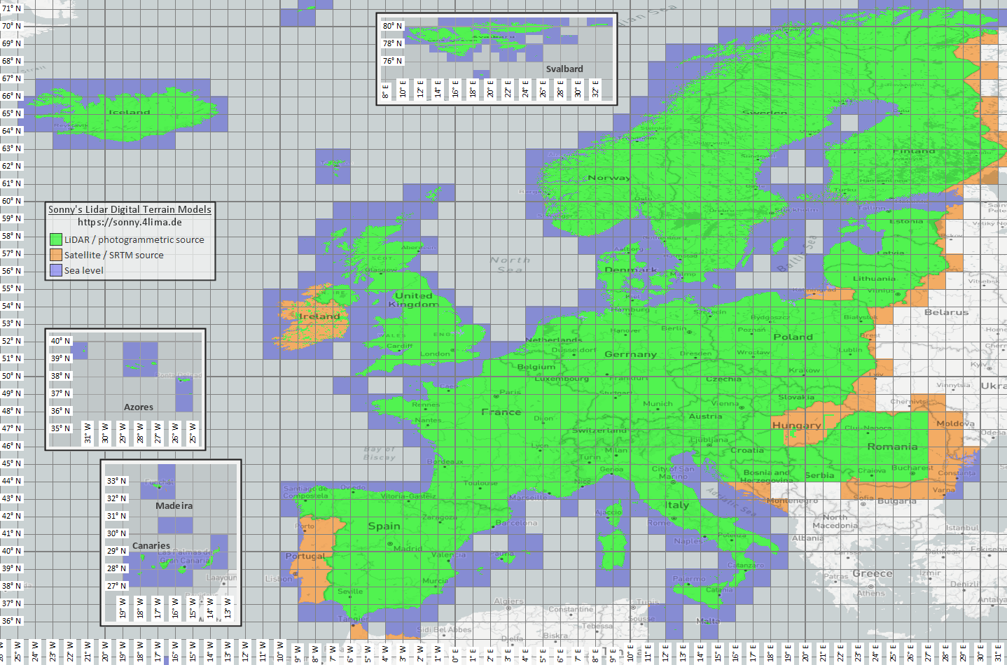
The next Picture shows the coverage of LIDAR DEM sources in my maps after the update (picture by the creator of the DEM files https://sonny.4lima.de/ ). It's the first time for quite a few eastern European countries to have LIDAR DEM data and first update for many parts in Italy as well as other countries. LIDAR DEM sources usually mean that the error in altitude is less than 2-3m even in forest (showing the altitude on the ground, while satellite sourced DEM sources usually have rather the altitude a bit below tree crowns).
Also I changed the 20m equidistance contourlines to show 10m interval up to 50m over sea level. Due to various bugs in the tools used to compile the contourlines - this update took many weeks of work by me as virtually every tool in the toolchain had some bugs that needed to be sorted first.
The other big update was that during the last month I redesigned the layout of the homepage - making it more coherent, exchanging many wordpress plugins that had aged/developped bugs with newer PHP versions - and made a more coherent website layout. I left the overall colour scheme of the website but harmonized many elements, removed many CSS bugs in the theme and some plugins - as well as correct some problems for mobile users. Also finally changed the SSL certificate to Let's Encrypt (I had bought just another 3 year multi domain certificate 3 years ago - as Let's encrypt has no multi domain certificates - and some very old browsers like Internet Explorer on Windows XP were not compatible with SNI - meaning running multiple SSL secured domains from the same IP address using different certificates for each website. However by now there is really no one using those browsers anymore - 3 years ago it was already less than 1% of my visitors and Windws XP is really dead).
Other Updates over the last months were plenty, e.g. updates to OSM usage of valley, railway=halt, adding information=trailblazed and reworked the naming scheme of ways to show a bit more keys/tags concerning road condition (e.g. trail_visibility - shortened as tvVALUE), fixed some access tags, rework of gates, entrances and barriers, improvements to restrooms/toilets, benches, picnik places, remove survey_point (too much clutter) and already last year in October a complete rework of POI visibility on modern Garmin GPS devices according to zoom levels.
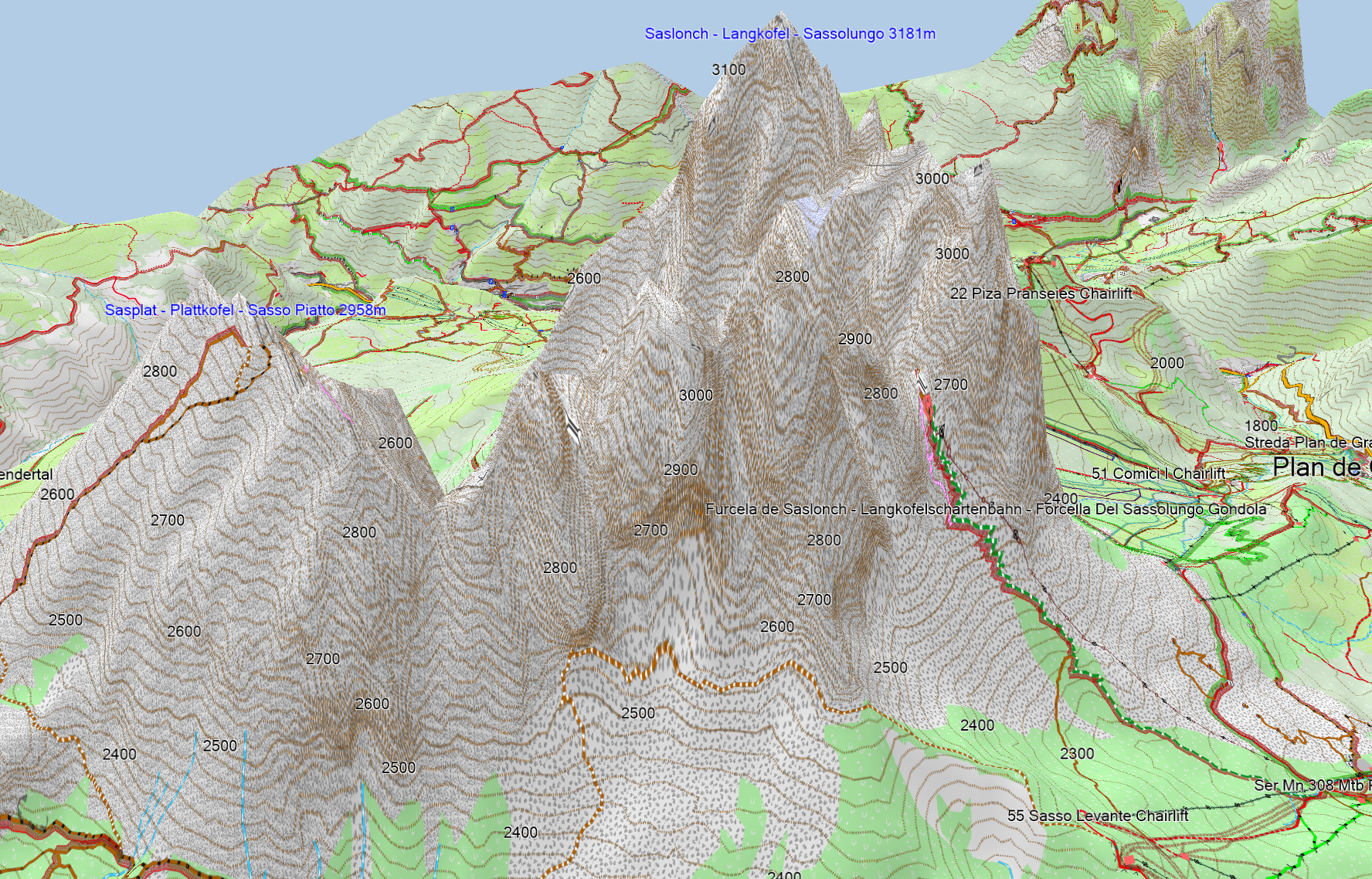
Below the Langkofel, Dolomiti in Italy - really close to reality even though it's so steep.
And here a typical comparison between LIDAR data and old quite good quality data - on first look it doesn't appear very different - but the crevease of the river is much more exact with the new data:
vs old contourlines

ich schaffe es nicht greatbritan and ireland zu öffnen
Wann wurden die Karten zuletzt aktualisiert?
Donnerstag auf Freitag diese Woche (Europa Kontinent Kartenetwas länger her), wobei Karten mit Englisch oder lokal immer abwechselnd geupdated werden im wochentakt