About the DEM Relief Maps
If you want to enable relief shading / shaded maps on your GPS device from 5km zoom level or higher - I provide here for OpenMTBMap members downloadable .img files for each country or continent.
I worked quite some time to optimise the speed/quality of the rendering on the devices - however note it will slow down map panning on your device.
In General you can simply use the continent .img files - only for Asia it is pretty big (and has a lot of tiles - so make sure to not go over the 2048/4096 tile limit on your device).
I've added the files for each country as well for those who just want to try it out or prefer very small download.
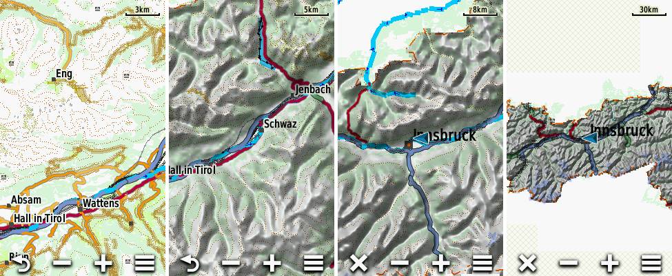
Screenshots from DEM on Oregon 600 - only Austria in this example. From Left: 3km scale (DEM not shown with Auto mode), 5km, 8km and 30km.
How to Use
Right now this is first version - it should work but I hope to still improve them a bit. To use them simply copy the .img file to the /garmin directory on your mSD card, then activate the mtbmap-DEM-XX (XX standing for abbreviated country) map on your device.
Attention in night mode the relief will never be shown. So if you try it out at night (or without GPS reception sometimes) - you need to deactive the night mode.
Device Setup
You should setup your device to show DEM to auto mode. You can do this in
Map Settings --> Advanced Setup -->Shaded Relief: Auto
If shaded Relief is set to Auto - it will show from 5km zoomed out to infinite (I hope to restrict this in future to 30 or 50km). Always make sure to have the devices Basemap active - it will really speed up map panning when zoomed out a bit.
3 Different Versions
I have only properly tested the first - standard Version - which is also the one I recommend to use. If you however want to try out a DEM shaded relief map for your device with higher detail level / better resolution you can try out the Experimental versions. They are available in Higher Detail, and in Highest Detail.
Note you should only send one version to your GPS device at a time from a single country. Else your device may not boot. However for testing you can e.g. use the Standard Europe DEM Overview map, and the Higher Detail DEM map from a single country like Germany or Alps.
Note also that the Higher Detail, and Highest Detail experimental versions have not been tested thoroughly - and they mainly make sense if you set Map Settings --> Advanced Setup -->Shaded Relief: Show Always.
If you want to know the last update time, MD5 Checksum or exact filesize of a download - just look into the MD5 link that follows each download.
Contourlines/DEM data:
The altitude data for the contourlines is from varying sources in the following priority (if available):
- LIDAR data from open government data and other openly available sources - collected and converted to hgt format by - Sonny - https://sonny.4lima.de This data is very very high quality and resolution - there is no better open data available according to my knowledge.
- ALOS World 3D30 - überall zwischen N60° und S60°
- SRTM 1" v3.0 - very rarely for some tiles missing in ALOS data - also only between N60° and S60°.
- Viewfinderpanormas 1" - then 3" - above N60° / below S60° as there is no SRTM data nor ALOS or LIDAR Data avialble.
- SRTM v3.0 by NASA 3" v3.0 (very very rarely, 8 tiles only)
more exact info which data is used where - inside the copyright.txt files.
Free Sample download of Austria if you have no OpenMTBMap membership:
- Standard Detail: DEM -Austria (MD5)
- Higher Detail: DEM -Austria (MD5)
- Highest Detail: DEM -Austria (MD5)


Hello, I downloaded the DEM file of China and found that the date is many years ago. When will the latest data be updated?
Ther will be no update. That’s a very basic DEM map, nothing will ever change. The actual map of China of course is regularly updated.
Should I use the dem to calibrate the altitude, or should I use the gps to calibrate the altitude? Which one is more accurate?
just leave it in automatic mode. GPS over time works very well on devices with a barometer. The DEM shading maps offered here are just for overview when zoomed out far – they work on many but not all devices. the detailed DEM is in the contourline maps.
Hallo Felix,
ich brauche Hilfe. Ich habe ein Edge 1030 und verwende seit 2021 deine Karten und Höhenlinien, nie hatte ich Probleme. Seit ich mir letzte Woche die aktuellsten Karten (.img) runtergeladen habe, sehe ich keine Höhenlinien mehr. Habe schon folgendes versucht:
– habe alle Karten und die Countourlines Dateien von der SD Karte gelöscht und neu drauf kopiert
– habe die SD Karte komplett formatiert und neu die Dateien draufkopiert
– die Höhenlinien sehe ich weder in der Deutschlandkarte, noch der Spanien Karte
– habe jetzt noch getestet, ob es denn mit der Europa DEM Datei funktioniert… aber auch nicht
Plastische Karte: Auto ist aktiviert, habe schon x-mal deine Anleitungen und auch alle Kommentare gelesen… ich bin verzweifelt, denn am Freitag fahre ich in Urlaub und brauche neben Karten auch Höhenlinien. Mit den Karten habe ich keine Probleme.
Ich habe übrigens auch versucht, ob ich vielleicht zu viele Kartendateien habe, und habe nur die Spanienkarte und Spanien DEM draufgelassen und natürlich aktiviert. Das Problem bleibt bestehen, sehe keine Höhenlinien.
Danke im Voraus!!
Spanien sind Höhenlinien ein extra Download im Höhenlinien Tab – DEM Karte ist nur für Übersicht – sprich ohne Höhenlinien.
Herzlichen Dank für die Antwort! Da hatte ich ein Brett vor dem Kopf. Ich habe mir jetzt die countourlines 20m runtergeladen. ABER: ich sehe immer noch keine Höhenlinien. Ich versteh das nicht… denn vor der Aktualisierung habe ich die ohne Probleme in meinen Karten.
viele Grüße,
K.
Für Windows musst du den Installer nochmals laufen lassen, und die Höhenlinien 20m anklicken. Mac siehe Tutorial und Cache löschen. Gerät direkt die Höhenlinien zusätzlich aktivieren (außer du sendest die Karte mit Höhenlinien integriert).
I tried to use the MD5 Versions of Germany,Badenwürtemberg und Canary Islands in my Garmin GPSmap 62s device but unfortunately nothing is displayed although I can enable and disable the maps in menu. All old maps are still OK.Is my device not supported?
MD5 is a hash, meaning a string to control if your download is 100% correct. If you want to use maps directly use the gmapsupp.img maps – unpack them – and move the gmapsupp.img (rename) into the garmin folder. Make sure that you go outside with GPS reception and make sure to only enable one detailed map at a time so there is no overlap with empty space of another map (sorry for the late answer – somehow missed your comment). Don’t use Baden-W. and Germany – it makes no sense – they are identical.
Hallo,
Auf welches Maplayout sind die DEM Karten eingestellt? Gibt es eine Möglichkeit das Layout z.B. auf Hiking umzustellen?
Beste Grüsse
Dem Karten haben kein Layout. Die erzeugen ja nur die plastische Karte, wenn weit herausgezoomt und die Option aktiviert. Wie stark die Schattierung ist bestimmt Garmin
Ah, ok, danke für die sehr schnelle Antwort. Die DEM Karte wird also zusätzlich zur eigentlichen Karte der jeweiligen Region auf das Garmin gespielt, richtig?
Ja, ist nur für DEM ab etwa 10 oder 20km Maßstab da.
I would like to download all of them, but I cannot simply do it via command line since the “I am a registered member”-cookie does not get transmitted then.
Is there an archive which contains all in one file?
Regards!
No – just download the continent DEM relief shading maps – that way you only need one per continent.
OK — but I would like to have it at country granularity level.
But I found a way to automate it (of course that does not bypass login requirement; works still only when I am logged in) by providing the cookie to `wget`, downloading one-by-one in order.
Hallo Felix,
die Fenix 6X kann die aktuelle Höhe per DEM information kalibrieren.
Wenn ich die “europe_ov” verwende kann die Uhr auf das Höhenmodell dort zugreifen?
Oder sind die Höhenangaben auch in den “normlen” Karten bereits integriert?
Eine Schattierung stellt die Fenix6X ja nicht dar (vermutlich weil die Auflösung zu klein ist und die Anzahl an Farben dafür nicht ausreichend wäre…)
Daher die Frage, ob es sinnvoll ist die europe_ov zu kopieren, oder nicht….
Vielen Dank,
Thomas
Ja Schattierung kann die Fenix 6x zum Glück nicht – wäre absolut sinnlos. ist es ja schon bei den Normalen Karten außer sehr weit herausgezoomt. Die ov ist nur für weit herausgezoomt – schnellere Anzeige der Schattierung. Das Höhenmodell an sich ist in den normalen Höhenlinien enthalten (also nur wenn du 10 oder 20m Höhenlinien aktiviert hast).
Super – danke für die Klarstellung (und das wie immer schnelle Antworten:-))
Hello,
I am a little bit confused about contourlines,shaded relief and Dem.
First Question:
I installed, on my device 66sr,using basecamp, openmtbitaly which have the contourlines already integrated.
The map show Shaded relief using Worldwide Dem Basecamp Nr.
I downloaded the Premium Dem relief for my country, Contours_Italy.img, copied it to the /garmin directory.
I can’t activate the mtbmap-DEM-XX cause there isn’t in hte list. There is only Worldwide dem basecamp.
2nd Question:
Are the Dem file used to calculate total ascet during/after activity?
Thanks for your cooperation
Sorry – contours_italy.img is not the relief map! Of course you cannot activate it – because Italy already comes with contourlines integrated.
The relief maps work a bit different on each device – and now they are not used for total ascent/descent – could be used for preview ascent on very long routes (over 70-100km) – again depending on the device.
What they definitely do – they allow you to show shading for further zoomed out maps – but this is usually not helpful anyhow. I offer them because some people may have use of them – I never use them myself.