Garmin recently released a very buggy new firmware for edge 1040, 840 and 540. There are two huge problems with this new firmware (21.x) concerning map rendering. All maps published June 02 or later are therefore adapted.
a) Layout in the maps is defined via a .typ file. In this typfile there are two ways to define how streets should render. One is by setting two colours, one for the line and one for the border. And the other is by using two colours and creating a simple bitmap (32x32px). Likely to increase contrast or whatever Garmin decided to render the border in 4x the width that is defined in the .typfile. This doesn't affect most of their modern maps as they only used a line color without border - but in many older maps Garmin also uses a border colour. Now it sounds like the obvious solution to just switch to bitmap instead of line/border - but the problem is that most garmin devices render bitmap lines different and it looks worse. As I believe that about half of my users use the openmtbmap/velomaps with Garmin edge devices I decided to remove the borders and render most streets in single colour only. Before most roads hat a grey/black border. The alternative to use bitmap lines instead I felt is worse.
b) the 21.x firmware devices do not respect the settings regarding labels correctly. Nothing I can fix here. You can chose however unter map layout to not show labels for certain categories.
I spent a lot of time changing all the different typfiles but I would still recommend you to not update. Rolling back is possible by putting an older GUPDTATE.GCD firmware file into the /garmin folder - however this fully resets the device so is quite annoying. You can prevent updates of garmin edge gps devices by placing a dummy GUPDATE.GCD file into the /garmin folder (rename a text file with no content but a blank/space to this). I don't know if other garmin devices will also roll out in future with this broken fimware. It had been reported to garmin on their beta firmware but they didn't fix it.
I had previously decided to remove the "Thin" layout from the OpenMTBMaps to save my time adapting it when I change things to the layout. After several requests I have now re introduced the Thin layout for the OpenMTBMaps and also added a thin layout to the VeloMap. It is 1px thinner than the classic/velo (legacy) layout. I think it's only useful for GPSMap 60/62/64/65 devices with low resolution displays - all other garmin devices have higher DPI. As sometimes people ask about which layout to chose - I add an explanation again here (and in other places in help files/website):
The new layout selector in the Windows installer with additional Thin layout
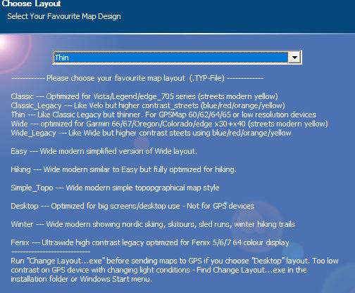
Basically the layouts differ on use case, line width and colour of roads. "Legacy" typfiles use the higher contrast blue/green/red/yellow street differentiation - while "modern" layouts use a lower contrast red-yellow road differentiation. The philosophy behind this is that on legacy typfiles you know exactly what kind of classification a street has, while the modern layout there is a more fluid approach from motorways to small roads that subconciously tells you the road class. Google maps is a prime example of modern type of layouts - while typical German road maps are the inspiration for the legacy layout. Modern layouts give you a better overview when looking at the map on a big screen/display as it's easier for the brain to class importance in an instant and looks nicer/calmer - while legacy layout gives a more exact classification but needs more time to process the information and looks less nice. The width of the layout should be chosen according to the DPI of your device and preferences. As most currently sold garmin devices (except smartwatches) are optimal in my eyes for the Wide layouts - special layouts like, winter, hiking, easy or topo are only available in wide style.
Which .typ file should I choose (OpenMTBMap) - Sorted from Thin to Extra Wide?
Thin - optimized for GPSMap 60/62/64/65 (2px small roads/trails/tracks)
*mthn --- Thin layout - like Classic legacy but even thinner lines. For low resolution Garmin GPS devices like GPSMaps series.
Medium width - - optimized for Vista/Legend/edge_705 (3px small roads/trails/tracks)
*clas --- Classic series - red/yellow streets - rather thin for lower DPI Garmin devices
*cllg --- Classic Legacy - Like above optimized for Vista/Legend/edge_705 series - blue-green-red-yellow streets
Wide - optimized for Oregon/Colorado/edge x30/edge x40/GPSMap 66/67 and more modern devices. (4px small roads/trails/tracks)
*wide --- high contrast layout, like classic but with white forest and wider streets/lines - red-yellow streets
*wdlg --- same as above - but blue-green-red-yellow streets
*easy --- Simple Layout with (nearly) no additional info over traditional topo maps. Same width as Classic. No add. lines for (mtb:scale(:uphill)/cycleway=*/sac_scale)
*hike --- Similar to easy but fully optimized for hiking.
*wint --- Winter - like hiking layout - but optimized for Winter Sports (does not show mtb/bicycle informations). Shows sledge routes, nordic skiing and skitouring routes.
*topo --- Simple topopgraphical map style - Easy to understand - high contrast.
*trad --- Mapsource/Basecamp/Qlandkarte_GT/Desktop --- General big screen/resolution layout. It is the easiest to understand layout and optimized for big screens (800x600 or bigger). Street colors similar to google maps. Medium contrast - therefore bad for GPS use.
Extra Wide - for 64 colour Display of Fenix watches / watches with MIP Display (5px small roads/trails/tracks)
*fenx --- Fenix - similar to Wide Legacy but optimized for Fenix series 5/6/7 watches which can only show 64 colours
Other recent Updates.
I have once again reworked a bit how to draw tracks and ways with mtb:scale information. I had changed this 2 years ago and now went back a little bit to how it was before hoping it's a better compromise. It's always hard to chose the different colours. In general dark colours are better contrast on Garmin GPS devices MIP displays - but some colours like purple, turqoise, yellow, green or red also stand out well. However purple usually is used for routes/tracks. while turquoise is used for showing the way you traveled for trackback and if used for roads could be easily confused with water objects. That's why I chose green for ways rated with mtb:scale and for mtb routes. Now brown (used for hiking trails sac_scale) actually has better contrast but green stands out more in the map. That's why I decided to use green for mtb trails and brown for hiking trails. As for colouring mtb trails like skislopes from very easy (green), easy (blue), intermediate (red) to difficult (black) - that would just work out for an overlay - but destroy any other kind of information in the map. Also with different skills of mtbikers the classicication in 4 levels is simply not enough, same goes for hiking classification on difficulty.
New contourlines for Italy and Republic of Cyprus. Since 2 months finally all of Italy is available with contourlines based on LIDAR data - before this was patchy for some regions only with the rest based on satellite DEM data. For Cyprus (just the South) contourlines are now finally also based on LIDAR. That kinda only leaves Portugal, Ireland, Hungary, Bulgaria, Greece and small parts of Romania and Croatia in the EU without LIDAR based contourlines. And of course quite a lot of bugs or adaptions to OSM keys/terminology I update as always.
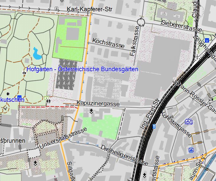
The reintroduced Thin Layout - Hofgarten Innsbruck.

Hallo Felix,
Seit du die Berandungslinien bei den Strassen entfernt hast, kann ich auf meinem Edge 1040 vor allem die weissen und gelben (geteerten, breiten) Strassen kaum mehr vom hellgrünen Hintergrund auseinanderhalten. Ich hab nun oft schon die (breitesten) Strassen auf dem Display übersehen oder einfach nicht bemerkt.
Ist das noch der Stand?
Wenn ja, könntest du diese Strassen evtl. dunkler einfärben, um einen Kontrast zum weissen oder hellgrünen Hintergrund zu haben.
Das könnte ich vermutlich auch selbst ändern, aber ich traue mich nicht … und weiß auch nicht wie.
Danke und viele Grüße für deine tolle Arbeit, Franz
Ich habe es schon etwas verdunkelt, aber mehr geht nicht vernuenftig – sonst ist das modern lazout genauso wie das classic layout. Aber Garmin hat in Beta Firmwares nun endlich den Bug erkannt und gefixed, ich werde wohl bald die Aenderungen wieder auf Ausgangspunkt stellen.
good morning!
First of all thanks for your work, really appreciated!
I downloaded the latest maps available for Italy but I still have some questions. In the article above you wrote about labels problems after firmware 21.X. Is this what I’m seeing in the picture attached as “stream”, “Ser” and so on? Or is this something else?
I also see that most of the streets/roads are showing correctly, just a few are still showing thick borders. I guess this is related to the type of road, correct?
Thank you again!
Matteo
sorry I loaded just one picture, here’s the other about labels
Yes, the label problem is related to the messed up firmware. Downgrade will solve it. As for the footway borders, could you take a screenshot somewhere where there is only a footway? And provide me a permalink to the place on osm.org?
Sure, thanks! Attached some pictures again and permalink to osm
1- https://www.openstreetmap.org/edit#map=19/45.92949/8.44039
2- https://www.openstreetmap.org/edit#map=19/45.92455/8.44447
3- https://www.openstreetmap.org/edit#map=18/45.93600/8.44026
The type of roads are not always the same I think, maybe it is related to some properties.. in example in picture 2, only the part in the picture is showing with thick borders, after the bridge instead it is ok.
The only difference I see is that the one with thick borders has label “foot: yes”, the other doesn’t.
thanks!
what is the date of your map?
I downloaded it 2-3 days ago, it should be from the 1st of July.
oh and yeah – will solve the black border problem with next update – as for the labels I cannot say right now.
Thank you! No hurry, it’s good enough, just tought it was good to give you some feedback.
Thanks again for your work
I just uploaded a new version of the Italy map that should be fixed (in most typfiles- I may have missed some lines maybe in some of the typfiles – it’s a bit hard to find in the editor). I also hope the labels are better now – if you still have broken labels please tell me. Most of those broken labels were due to a bug in the editor I use for editing the typfiles. Some weird labels may still be there due to bugged firmware however – I would like to try to analyze a bit more but so far I prefer to keep my own edge 1040 on the old non broken firmware.
Sorry, I can guess the date – I found the bug related to the black lines. I’m still trying to find the bug for the labels. Not sure what is going on there yet. Could be a bug again in the editor for the .typ files which only happens on the new firmware or could be a straight firmware bug.
Not sure why but I can’t reply to the message from today.
In any case I loaded the new map and can confirm that the borders are ok now, thanks!
About the labels, I still see them on the map, please check the picture below. Not a problem for me but let me know if you want to test something else, I’m available to help.
OSM position: https://www.openstreetmap.org/edit#map=17/45.93110/8.45279
Thanks again!
I think I will have to give up on the labels. Maybe there will be a solution via setting them transparent – but not sure that can work. It’s like the edge now completely ignores the typfile in this regard.
No worries, it’s more than good like this!
thanks again
Vielen Dank!