Hi Everyone - wishing you all a good outdoor/MTB season this summer!
To make your biking and outdoor activities even better - I invested a lot of time - partly together with a graphics designer - to improve the layout of the maps regarding to making them nicer to look at. Previously I had tried to design all elements so that they are easiest to distinguish - that however caused the some not so important things - like the differentiation between industrial or residential quarters to stick out too much - while for most people the main importance is if you are in the nature or in a build up area. It's still easy to distinguish between shopping, industrial or residential quarters - but the different places don't pop out of the screen anymore - leaving better contrast to streets and trails - so things that really matter. I also made buildings much more similar - I think the old differentiation between simple buildings and those with touristic or public usage was not as important as to make them a darker grey. Landfills are now moved to show only at very high detail - they showed too early.
Also for all layouts residential streets at resolution 23 (300m) are now shown identical to resolution 24 (200m and below) - I did this to save some screen estate in resolution 23 but I think it's too confusing - increases the learning to read the map too much.
The second big change is an addition of a more standard Topographical map layout. It does not show any information that you would not expect in a normal topographical map for hiking - so it is much easier to read. I therefore also made mtb, bicycle and hiking routes much thinner. They are still visible but much less obvious. It's very simple - tracks get red colour, pathes (singletrail) get brown colour. The more dashed the harder/more difficult/worse condition. There is no more differentiation between residential roads and service roads or tracks with tarmac surface (this differentiation is still visible in the hiking layout) as standard topographical maps also do not differentiate this. An exception to this I made with pedestrian zones - they are in most maps not differentiated - but I kept a differentiation for them. I am thinking about modifying the hiking layout a bit therefore - maybe remove all mtb routes and bicycle routes from it? I usually think hikers like to know them too - but in that case they could use the new simplified topographical map layout which is not specific to one activity.
The simple topographical layout also exists for the VeloMap.
Some more changes over the last weeks: add leisure=track for bikeparks where highway=path is not used (happens sometimes), Fixed a bug that ways with route=hiking were shown dominantly in the VeloMap (so you could assume they have better surface - only applies to ways with unknown surface/tracktype/smoothness). Place=locality POI moved from resolution 23 to 24. They are sometimes used excessively.
And some weeks ago - but only written about in the VeloMap newsletter:
I updated the VeloMap compilation process to include an option to show 20m contourlines but no buildings. With gmapsupp.img downloads this has been possible now for over a year - however on your PC/Notebook you could only chose to have map without buildings and without contourlines.
Now there are the following choices for the VeloMaps:
- Map without buildings and without contourlines
- Map with 20m conturlines without buildings
- Map with 20m contourliens including buidings
- Map with 10m contourlines including buildings
Of course you can also install a separate buildings only map, 20m contourlines map and 10m contourlines map if you prefer to create your maps with Garmin MapInstall instead of using the gmapsupp.img downloads. As the buildings layer overlaps sometimes street labels - I will not do this for the OpenMTBMaps - as I assume most people want to have buildings in the OpenMTBMaps, while I guess for VeloMaps it's oly one third or maximum 50% of users wanting to have buildings shown.
I have added a new section to this website with screenshots showing the differences between the layouts: https://openmtbmap.org/about-2/map-legend/
So here some screenshots showing the changes:
The new cleaner layout - OpenMTBMap Wide layout (very similar for VeloMap Wide):
vs the old Wide layout:
The same was done for the desktop layout (I first thought about removing it altogether - because the new layouts are quite nice on desktop too - but yeah desktop layout with lower contrast is still nicer on desktop:
- so the new desktop layout below.
I still have to do some work in implementing those changes for the Fenix layout.
Now on to the new Simple Topographical map layout:

vs the Hiking layout:
vs the wide layout:
And here another screenshot of the new simple Topographical map layout:
Servus,
ich konnte das Thin Layout, das für die Mapgeräte empfolen wird nicht mehr finden. Welches Layout ist für das Map 66 empfehlenswert?
Classic oder Classic Legacy (clas/cllg)
Hallo Felix,
x-mal habe ich versucht, die mtbspain herunterzuladen und für mapinstall am PC zu installieren.
Werder ohne, noch mit Konturlinien (werder Unicode noch Nicht-Unicode) war die Installation erfolgreich. Beim starten von Mapinstall erfolgt eine Fehlermeldung, siehe Anhang. Zuvor habe ich ohne Probleme mtbandorra mit höhenlinien installiert.
Was mach ich jetzt falsch? Bisher lief der Kartendownload ohne Probleme.
Gruß Helmut
Hi,
is it possible to revert the old layout somehow?
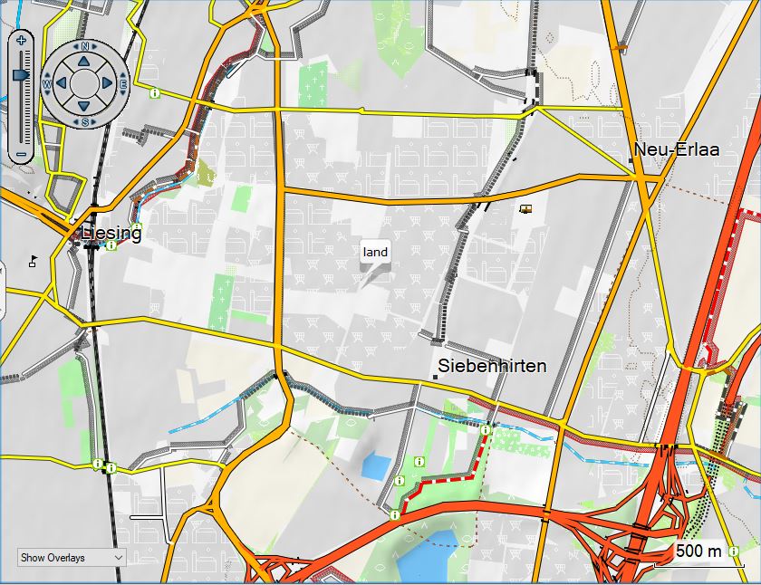
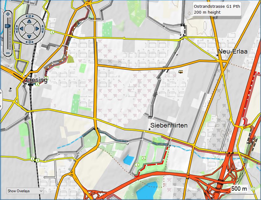
The problem is that at 500m scale zoom or large (e.g. 800m) hiking tracks aren’t visible anymore. Neither on desktop nor Fenix watch. It used to work and was super handy. But with 300m zoom is rather too large.
See attached (same area, at 300m scale on the left and 500m on the right).
Thank you!
No – I will not revert because in well mappped areas it got too many details. Just use details high (available both in Basecamp and on all devices) and then you have 300m detail at 500m zoom setting. With higher you would have 300m at 700m setting with highest at 1.2km.
ok, will dig how I change level of details then.
Hello Felix, just downloaded new map update, I noticed strange behaviour with alpine huts (classic layout).
On basecamp and on my Garimin Edge 830 with zoom up to 70m name is rendered with the name tag (As I expect). from 80m and beyond the name is rendered as “alpine hut”.
Is it wanted or a bug? Attached you can see the different names at different zoom level.
Hi thanks for notifying me – that’s a bug and should be fixed in the next map update (it does not affect all alpine_huts – only some).
ich habe die 7zip-date auf den rechner kopiert und entpackt. anschliessend habe ich die cmd-datei gestartet und die option 9 (topo) gewählt. auf dem bildschirm erschient die meldung, dass die layout erfolgreich gewechselt worden ist. zum schluss kopierte ich die datei auf mein garmin edge 1030.
auf dem garmin edge 1030 ist die karte aktiv – ich sehe aber keine topo-ansicht.
p.s.: ich habe einzog die gmapsupp.img datei umbenannt.
hallo, ich wollte heute das neue topo-layout auf mein edge1030 laden. wenn ich nun aber über die cmd-datei ein neues layout erstelle, ist die datei immer gleich gross. auch sehe ich auf meinem edge1030 keine topo-ansicht, sondern “nur” ide normale ansicht.
mache ich was falsch oder iw komme ich zur topo-ansicht?
Ich weiß nicht genau was du machst – Ist am Ende der change_layout cmd batch Skript eine Erfolgsmeldung? Hast du die change_layout direkt am GPS Gerät laufen lassen? Bzw wenn am Computer – die dabei veränaderte gmapsupp.img Datei auf das edge 1030 kopiert?
ich habe die 7zip-date auf den rechner kopiert und entpackt. anschliessend habe ich die cmd-datei gestartet und die option 9 (topo) gewählt. auf dem bildschirm erschient die meldung, dass die layout erfolgreich gewechselt worden ist. zum schluss kopierte ich die datei auf mein garmin edge 1030.
auf dem garmin edge 1030 ist die karte aktiv – ich sehe aber keine topo-ansicht.
p.s.: ich habe einzig die gmapsupp.img datei umbenannt.
hier noch ein screenshot auf die dateien
Ah – ich nehme an dass dein Problem mit dem edge 1030 an sich zu tun hat – siehe hier: https://openmtbmap.org/about-2/compatibility/
(x30 edge Sektion). Sprich du siehst das verkorkste mountain/bzw hochkontrast Layout.
Du könntest gmaptool installieren – und die mtbalps_topo.img da ins Fenster ziehen – gmaptool zeigt das .typ file an. Aber ich bin sicher dein Problem ist auf obigem Link erklärt.
danke für die prompte antwort.
da ich in den nächsten 2-4 wochen auf das «edge1040 solar» wechsle, hoffe ich, dass sich dann das problem “löst”.
Ich nehme an – die Edge X40 Serie wird genau dasselbe Problem haben – aber es ist ja eh einfach lösbar durch anderes Profil und Klassischen Modus.