Video Tutorial how to send the maps. For more Video Tutorials explaining all the basics go here: https://openmtbmap.org/tutorials/beginnners_windows/
About the Maps - Please Read
Maps are available Worldwide. They are usually updated every Friday.
- Map Data
All maptiles are compiled with mkgmap using map data from openstreetmap.org & Contributors. You can use and edit the map data by visiting openstreetmap.org.
Thanks to Geofabrik for providing the map data snapshots which I use to create the maps.
-- For Copyrights please see the Installer or if you unextract the installer see the file copyright.txt.
Contourlines/DEM data:
The altitude data for the contourlines is from varying sources in the following priority (if available):
- LIDAR data from open government data and other openly available sources - collected and converted to hgt format by - Sonny - DEM Altitude Profiles This data is very very high quality and resolution - there is no better open data available according to my knowledge.
- ALOS World 3D30 - überall zwischen N60° und S60°
- SRTM 1" v3.0 - very rarely for some tiles missing in ALOS data - also only between N60° and S60°.
- Viewfinderpanormas 1" - then 3" - above N60° / below S60° as there is no SRTM data nor ALOS or LIDAR Data avialble.
- SRTM v3.0 by NASA 3" v3.0 (very very rarely, 8 tiles only)
more exact info which data is used where - inside the copyright.txt files.
The default equidistance is 20m - meaning every 20m altitude one contourline. For all countries with the highest point below 1000m - the default equidistance is 10m. However due to popular demand I also additionally offer optional 10m contourlines for all countries with altitude above 1000m. The installer cannot integrate the optional 10m contourlines into the maps however.
Programs to Display the OpenMTBMap
Besides being shown on (nearly) all Garmin GPS devices - most People will use Garmin Basecamp (v4 or later) to show the maps on their Desktop and plan tours/trips.
For anyone on the good side of earth AKA Linux - OpenMTBMap.org maps are also correctly shown in Qlandkarte_GT - QLandkarte_GT is compatible with all big OS (Linux, MacOSx and well Windows too). Linux users can alternatively install Mapsource 6.13.6 in WINE. The .exe files can be unpacked with 7zip. After unpacking you find instructions for Qlandkarte / Linux use in a .txt file (informations... .txt).
For Linux/Unix users there is also a script to unpack the maps, and automatically create a gmapsupp: https://github.com/btittelbach/openmtbmap_openVeloMap_linux You can unpack the .exe with 7-zip , ( Linux users use p7zip-full --> see here for more details), MacOSx Users can use "Unarchiver" (requires v3.0 or newer) . After unpacking you find instructions for Qlandkarte / Linux use in a .txt file (informations... .txt).
For General Use - Basecamp is much better than Mapsource by now - The only thing were Mapsource is better is selecting parts of maps to send. The only usable Mapsource version is 6.16.3. Mapsource versions 6.14 to 6.15.6 are complete junk. Also note that Mapsource versions prior to 6.16.1 do not show all ways and pathes so they are not really usable.
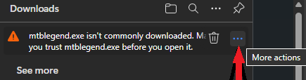
Windows Smartscreen / Microsoft Edge / Norton
Since 11 December I'm using a new individual certification code signing certificate (hosted on google cloud key management service which made it super complicated to employ - as storing certificates on a server is not allowed anymore - so FIPS compliant storage made it a nightmare to get right) - however somehow microsoft is still not recognising it as safe. In the past this worked much quicker. It's sadly still impossible for me to get the Azure cloud signing certificate which would offer instant trust - as it's not available to residents in EU right now.
At the same time, I heavily recommend to use neither Norton Antivirus/Avira or Mc Affee - they constantly have false positives so create more danger than not using them. Your best defence is not downloading/clicking on suspicous things and not downloading stuff from shady websites. If not using Windows Defender which I think is pretty good, I would recommend Avast, Malwarebytes, Eset Nod32 or Kaspersky.
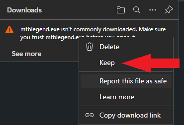
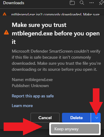
Download using Microsoft Edge
- Click on the three dots (More Actions) - they appear once you move your mouse towards the right corner of the download.
2. Click on Keep
3. Click on the small arrow on the right - then click onto Keep Anyway
If downloaded with any brother other than Microsoft Edge (I highly recommend not to use Edge - better use Brave or Firefox) after double clicking the .exe in your file browser:
- Click on More Info

2. Click on Run anyway
Problems - Help - Tutorials
Beginners Guide can be found here: get started with OpenMTBMaps
Install Basecamp/Mapsource: tutorials/install-mapsource/
Install the OpenMTBMap on your PC: tutorials/install/ explains the options of the installer.
Send Maps to GPS with Mapsource/Basecmap: tutorials/send-maps-to-your-gps/mapsource/ I recommend to allways send maps to an external data card and not internal memory. (this way if something goes wrong, or maps would be damaged you run less danger of wrecking your GPS).
Alternative: Use create_gmapsupp.img.bat and place the newly created gmapsupp.img into /garmin folder on your GPS. Address search cannot be included this way. If you use create_gmapsupp.img_with_mkgmap address search will be enabled, but you need depending on the size of the map quite a lot of free RAM.
Send maps to GPS with mkgmap (for Unix users): tutorials/send-maps-to-your-gps/mkgmap/
Basecamp Error / debug Mapsource: There is a problem with the MapSource / Basecamp registry. Please re-install Mapsource and start again Solve with Mapsource Fix Or with Mapset Toolkit
Please also read the FAQ
Change Layout and Contrast of the maps
On installation you can choose the layout of the maps. Traditional layout is for Qlandkarte GT, Mapsource and Basecamp and offers a good layout and design for big screens. On the GPS thin, classic and wide or easy or hiking offer high contrast for best orientation while riding your bike or hiking.
In order to change the layout - simply run openmtbmap_country_change_layout.exe (this is also linked in your Start --> Programs Folder for each map). This also enables you to quickly change the layout before sending maps to your GPS device, and then quickly change it back for better planning on your desktop.
You can adapt the .TYP-files, which are responsible for the layout - and therefore the map colours, to your liking by using http://maptk.de/. Do not use because it is not fully compatible and may corrupt the .TYP-file.
Compatibility - Unicode vs Non Unicode (cannot authenticate maps)
Unicode is needed to display several alphabets in one map. Non Unicode maps can only display a single alphabet - e.g. kyrillic and latin - but not both. However Garmin blocked using Unicode maps in part of a broken copyright protection on newer GPS device series.
Newer Garmin devices cannot use free unicode maps (except if you hack the firmware) - usually a "cannot authenticate maps" message which show on boot. The following Garmin outdoor devices are affected:
- All Garmin devices presented 2016 or newer
- Edge 1000
- Epix
- Etrex 20x / 30x (not "etrex 30")
- Etrex Touch 25/35
- GPS Maps 64 series
- Montana 610, 680
- Oregon 700,750
- Some recent Nuvi devices - as well as some super old devices that do not support Unicode. (E.g. Garmin Vista C, GPS Maps 60 C)
you will need to download the "Non Unicode" version of the map. Only maps of regions where several different scripts are used - are in unicode. I've listed the non unicode maps however also unter the unicode header for convenience (actually only maps with (unicode ) following their name are actually in unicode.
Also english version of maps is only available for countries/regions not using latin only.
SD Cards
This is not about the maps but in general Garmin units that have a microSD card slow only accept SDHC cards - SDXC cards will not work. Max 32GB size and you need to format it with FAT32 (not exFAT). Be careful with 32GB cards which are available as both SDHC and SDXC. 16GB and smaller usually are always SDHC.
Garmin Edge x30 or newer
Garmin introduced a completely broken high contrast mode - that washes out the colors of the maps. Either disable the high contrast mode on the map visibility section. Or delete the \Garmin\MapThemes\Mountain.kmtf (sometimes also called \Garmin\MapThemes\Mountains.kmtf ) file (back it up if you think you ever want to use that mode. Since the newest firmware in July 2021 you need to enable classic mode -
, select a profile, and select
- Classic: This shows the OpenMTBMaps / VeloMaps as intended, however POI are now shown from Edge profile.
- High Contrast: Complete fuckup by Garmin - because they are not able to make their own maps high contrast in first place.
- Mountain Biking: Complete fuckup by Garmin - because they are not able to make their own maps high contrast in first place.
Language and Codepage
Default - Local Language Unicode. All labels / street names are exactly like in the name tag of OSM. Note for any country that uses latin - the default will be latin1 and the options below are not available. An exception is the South America continent map that is additionally available in English Non Unicode. For USA/Canada this is also the only option. For European countries using latin if you want the English version - you can use the European continent map that is available in English versions.
English Unicode: If available in OSM - English or other European language translation is used. If no translation is available in OSM, the local name tag is used.
Local Language Non Unicode: Same as default but instead of Unicode the local codepage is used. So some characters may need to be transcribed automatically in creation. Codepage is always the local default codepage.
English Language Non Unicode (always latin1): If available English or other European language translation from OSM is used. If not names are transcribed to Latin.
Current Issues
The address search is not working consistently. Most problems are due to inconsistent data structures in OSM address data.
- General: Autorouting over longer distances on GPS works only with Via Points. Solve with WinGDB: plan-routes-efficiently
- Autorouting needs attributes like tracktype, bicycle routes, mtb:scale, sac_scale, mtb routes and others to work well. So keep care to enter those details into OSM. (not all are needed, but enough for me to guesstimate wether a street is cyclefriendly/mtbriendly or not).
- Note sometimes sea/lakes are missing/emtpy. This is not an issue, but currently not differently possible. It is usually a problem in OSM data.
Notice on Updating Maps
If you want to be notified by email on map updates please go to the frontpage and enter your email address in the subscribe field of the left sidebar. You only get an e-mail when there are changes besides a simple map data update. Map updates are usually every Thursday night / Friday morning. You can look at the server to see the date of map upload. To update the maps, simply run a newer .exe Download.
Overlapping maps in border regions
While you can join maps of different countries, routing over the boundary is a bit shaky, and you will have one map overlaying the other with white background. As long as mkgmap cannot create randomly shaped overview maps (currently only rectangles), this problem is not solvable. There is however the possibility to download a Europe map, which will be updated every 4-6 weeks. Get Europe Map here (donation needed): https://openmtbmap.org/support/europe-map/
VeloMap and OpenMTBMap of the same Country -- Problems
If you install an OpenMTBMap and a VeloMap of the same country with contourlines as separate download, you should only send the contourlines once (meaning with either Openmtmbap or VeloMap of the country). Else you GPS might not show the maps, or worse not even start until maps are deleted. There are several possibilities.
a) Install both maps without contourlines and contourlines separately (install separate contourlines only map option in installer). You have not trouble.
b) be careful here: Select the map as usual in Basecamp/Mapinstall, then go to the list of the selected tiles ready to be sent to the GPS, scroll down to the bottom, and unselect the contourlines only tiles from the list.
-- This is not a problem with countries where contourlines are fully integrated like Germany, Alps, Austria,......
Feedback
Please comment if you like theese maps or even better tell other people about them (forums, blog about it, twitter, etc…) In case maps break Basecamp or don't work - please write exactly which downloads don't work and the time of download as well as your OS and Basecamp version.. Please also look here https://openmtbmap.org/download/#problems-help-tutorials or in the FAQ
Map Downloads by GWDG
Premium maps are only downloadable for people who have a OpenMTBMap membership. For last map update: please look at recent posts for changes - usually maps are updated at least every 7 days with updates on Thursday/Friday.
To check the last update time for a map - just click onto the MD5 link.
Contourlines Premium Downloads
Most countries, especially the popular ones, have the 20m contourlines already integrated. However for several countries the contourlines are rather large (rule of thumb if contourlines have more data than the maps) and I integrate them, but you need to download them separately (once). The installer will ask for the contourlines file as soon as you activate the checkbox to integrate the contourlines in the installer. You do not need to extract the contourlines - this will be done by the installer (and is only needed once. On updates you don't need to redo it).
In general it is fine to only update the map, as I try to change the contourlines as seldom as possible. The 10m contourlines always have to be downloaded once - the installer will ask for the 7z 10m download and unpack and install them for you if you activate the 10m contourlines checkbox.
If you get the message - "cannot authenticate maps" or you have you have one of the following devices:
- All Garmin devices presented 2016 or newer
- Edge 1000
- Epix
- Etrex 20x / 30x (not "etrex 30")
- Etrex Touch 25/35
- GPS Maps 64 series
- Montana 610, 680
- Oregon 700,750
- Some recent Nuvi devices - as well as some super old devices that do not support Unicode. (E.g. Garmin Vista C, GPS Maps 60 C)
you will need to download the "non unicode" version of the map instead of the unicode version. So get the map from the "non unicode OpenMTBMap" tab instead. Only maps of regions where several different scripts are used - are in unicode. If Latin is the predominant script - then of course no unicode map is offered. If your device can display Unicode maps - then of course get the standard version - meaning Unicode if needed for the country.
Note1: if you install the non Unicode version of a map - you will overwrite the Unicode map. You can only have either or installed.
Note2: The contourlines are identical for openmtbmap/velomap and unicode or non unicode. You only need to download them once. On updates it's enough to re-download and reinstall the map installer.
Note3:Here only those countries are listed - where the standard download is Unicode. If you don't find a country here - look at the standard downloads.
Note4 - local language maps of: Sri-Lanka, Nepal and Cambodia are in latin1 - so the local language maps are not very useful. There is no ANSI Codepage available (besides Unicode) that would support the script/garmin units. Israel-Palestine map is in hebrew (so the Palestine area is not useful). Afghanistan codepage is for Dari - Pashto is not supported outside of Unicode.
Language and Codepage
Default - Local Language Unicode. All labels / street names are exactly like in the name tag of OSM. Note for any country that uses latin - the default will be latin1 and the options below are not available. An exception is the South America continent map that is additionally available in English Non Unicode. For USA/Canada this is also the only option. For European countries using latin if you want the English version - you can use the European continent map that is available in English versions.
English Unicode: If available in OSM - English or other European language translation is used. If no translation is available in OSM, the local name tag is used.
Local Language Non Unicode: Same as default but instead of Unicode the local codepage is used. So some characters may need to be transcribed automatically in creation. Codepage is always the local default codepage.
English Language Non Unicode (always latin1): If available English or other European language translation from OSM is used. If not names are transcribed to Latin.
OpenMTBMap (and VeloMap) maps Premium Download in Mac OSx format (gmap)
I have decided to make available all OpenMTBMaps and VeloMaps also in gmap format for Mac OSX. Please get them from here: https://openmtbmap.org/download/macosx/
Note for Premium Members:
Your account does not allow you to login into VeloMap - However you can download all VeloMaps from here for Windows users: https://openmtbmap.org/download/velomap/
Mac OSx user - just scroll down here on the normal macosx download page: https://openmtbmap.org/download/macosx/
Gmapsupp.img Downloads are here: https://openmtbmap.org/download/gmapsupp/
Note if you are not a OpenMTBMap member - please directly go to www.velomap.org/
I’m following the instructions and keep getting this error notification.
Well i assume you should do exactly what told, feed the canada_contours.7z to the installer when asked – did you download the 20m canada contours from the windows section into the same folder as the instaler?
Ergänzend zu meinem Post der einen Fehler hat: natürlich habe ich jeweils das richtige Hackerl 20m zu den 20m Linien gesetzt usw
Karte und Höhenlinien wurden heute runtergeladen
Mit den 20m Linien funktionierts mit den 10 m Linien nicht
Dir ist klar das für die 10m Höhenlinien ein eigener Download ist? Bekommst du kein Fenster zum auswählen der windows_contours_europe1m.7z?
In dem Fall ist es am einfachsten du löscht die Europakarte (also das Verzeichnis) und installierst sie noch einmal komplett neu.
Ich dürfte alles richtig machen, bzw verlangt die Installation ja eh alles “deppensicher” was es braucht.
Das Löschen des gesamten Ordners (europe) bringt leider auch nichts. Ich hatte mal eine alte Europakarten Installation mit 20m Höhen installiert, diese müsste dann ja wirklich nicht mehr vorhanden sein.
Egal, mit der funktionierenden Installation mit den 20m Höhenlinien bin ich auch mehr als zufrieden.
Danke!
Ich habe es gerade selber ausprobiert – ich nehme an deine 10m Höhenlinien sind veraltet. Ich habe mtbeurope.exe, und beide 7z frisch heruntergeladen und es installierte Problemlos. In den Höhenlinien sollte eine Datei mit Namen: version_10m24_02-Jun-2025.info vorhanden sein – ich nehme an die hat bei dir ein anderes Datum weil du verlatete Höhenlinien hast. Bitte überprüf das mal.
Danke fürs Nachforschen. Ich komme jetzt längere Zeit nicht mehr zu dem Rechner auf der die Daten liegen und kann nicht nachschauen. Ich melde mich später.
Ich habe die Höhendaten von der Rubrick “10m Equidistanz Höhenlinien für Windows” – “Kontinente Höhenlinien:” – “Europe (MD5)” vor 3 Tagen runtergeladen. Die 10m Datei hieß “windows_contours_europe10m.7z”
Genau da habe ich meine auch heruntergeladen lokal. Evtl hattest du noch eine ältere Version rumliegen -die neue beim Download hat ein +1 im Dateinamen bekommen – und daher nimmter der Installer die ältere? Also es funktioniert auf jeden Fall wenn man alle 3 Dateien neu herunterlädt. Was auch möglich wäre – du hast eine sehr alte mtbeurope.exe/7z genommen – sprich älter wie Juni 2025 – die bräuchte natürlich ältere Höhenlinien die es nicht mehr gibt.
ups sorry- nein du hast keine ältere version des installers genommen – ich sehe ja das aktuelle DAtum am screnshot.
Hallo Felix
Habe die Europa Karte (mtbeurope.7z (MD5) Unicode) mit Hackerl „Map with 20m contourlines – Attention….“ installiert und bei der Installation der 10m Höhenkonturlinien (windows_contours_europe10m.7z) bricht die Installation mit dieser Meldung ab….siehe Attachment
„…you need contourlines last updated on version _10m24_02-Jun-2025.info! You have outdated contourlines…..
Dasselbe auch mit den 20 m Linien (europe_contours.7z)
Win 11Pro 64 bit
Was mach ich falsch?
Grüsse Peter
Norton 360 verschiebt die “mtbalps.exe” in die Quarantäne mit der Meldung WIN32:MalwareX-gen(Tri)!!!
Das Gleiche passiert auch mit der uninstall.exe von OpenMTBmap_france.
____________________________
Details
Name der Bedrohung: Win32:MalwareX-gen [Trj]
Bedrohungstyp: Trojanisches Pferd – Diese Bedrohung gibt vor etwas anderes zu sein (z. B. ein Bild, ein Dokument oder eine andere Datei), um Sie dazu zu verleiten sie auszuführen und so Ihren eigenen Computer zu infizieren.
Status: Verschoben nach Quarantäne
Optionen: Fehl-Erkennung melden
Erkannt durch: Auto-Protect
Auf PC von: 04.05.26, 21:00
Zuletzt verwendet: 04.05.26, 21:00
Startobjekt: Nein
Unbekannt
Es ist nicht bekannt, wie viele Benutzer in der Norton-Community diese Datei verwendet haben.
Unbekannt
Die Dateiversion ist gegenwärtig unbekannt
Hoch
Das Risiko dieser Datei ist hoch.
____________________________
Quelle
Speicherort: local://*C:\Users\hdt47\Downloads\mtbdach.exe https://openmtbmap.org/de/?s2member_file_download=odbl/mtbdach.exe
____________________________
Aktivität
Pfad | Typ | Status
C:\Garmin\OpenMTBMap\dach\OpenMTBMap_dach_uninstall.exe | Datei | Repariert
C:\ProgramData\Microsoft\Windows\Start Menu\Programs\OpenMTBMap\OpenMTBMap_dach\Uninstall.lnk | Datei | Gelöscht
Siehe den Hinweis dazu auf der Downloadseite – meine Empfehlung ist Norton mit einem anderen Antivirus auszutauschen – da es absolut Schrott ist mit der False Positive Erkennung.
Ich möchte die Contourlines Europe installieren… Wenn ich die Datei “install_openmtbmap_contourlinesonly_europe.bat” ausführe geht es nach dem Schritt, bei dem man die Dicke der Höhenlinien (ich nehme an für ein Garmin GPSMAP wäre das die 5) nicht weiter… Was mache ich falsch? Beste Grüsse & vielen Dank zum Voraus, Martin
Bitte lösche mal “echo off” per texteditor in dem .bat File, und schau dann welcher Fehler angezeigt wird. Wie hast du die install… erzeugt? Per create_mapsource_installationfiles_with_mkgmap.bat ?
Gut möglich dass die create_mapsource batch files nicht mehr richtig funktionieren – die sind eigentlich nicht mehr benötigt. Was möchtest du also genau erreichen? Die Höhenlinien von Europa in Basecamp/Mapsource installieren als separate eigene Karte? Das geht einfacher mit der mtbeurope.exe beim ausführen und wählen der entsprechenden Optionen.
Wo finde ich die Europamap in “non unicode”?
Gruß
Unter dem Non Unicode Header entweder in lokaler Sprache oder Englisch. Zwei Dateien (mit Höhenlinien 3)
Besten Dank für die schnelle Hilfe.
Gruß
Also bei Kontinente – CTRL-F hilft…
Habe die Euro-Map in “non unicode” gefunden.
Gruß
Hi, Felix.
I have downloaded some Windows maps.
All work well, except the Andorra map, that my system recognizes as a virus i i can’t install it.
Could you please help me?
Thanks in advance.
Read what I write about Norton antivirus. Please use a proper antivirus or you will need to use the gmspsupp.img map or Mac osx maps instead – you can use the map osx format maps also under windows.
Hi. I have downloaded the Andorra map (for Windows), but my system recognizes it as a virus.
Other downloads work well.
Could you help me?
Thanks
There is a problem with the MapSource / Basecamp registry. Please re-install Mapsource and start again > How can I fix the bug in Basecamp? I want to intsall the Europe map.
The question is how did this start? With installing the Europe map? Then make sure to correctly install it again with the correct .7z files. If not uninstall the map that caused it. You can check for errors and corect them with “mapset toolkit” – needs to be run with admin rights to check for errors.
Sorry for taking so long to answer
kan geen kaarten meer douwloden
Please read the section about smartscreen above on this page.
Habe den Browswer gewechselt. Der Download hat gut funktioniert.
Vielen Dank für den Tipp.
Habe gerade etwas unter dem von dir gesendeten link gefunden.
Welche Anleitung meinst du bitte?
Den Text unter Windows Smartscreen / Microsoft Edge hier auf der Seite in der Anleitung
Hallo Felix,
nach der Einrichtung eines neuen Windows-PC habe ich Base Camp installiert. Beim Download z.B. der Deutschlandkarte erscheint der Hinweis, dass diese Karte nicht häufig runtergeladen wird und ich sicherstellen soll, dass ich diesem Download vertrauen kann. Die EXE lässt sich nicht öffnen.
Kannst du helfen? Vielen Dank vorab.
Beste Grüße
Gunnar
Schau mal in der Anleitung, da habei ich einen Punkt diesbezüglich hinzugeüft.
Windows Smartscreen / Microsoft Edge