I recommend simply using the Installer to install OpenMTBMaps. However MapsetToolkit is great for checking all maps installed, cleaning up, and removing errors. Therefore I show this too....
Sometimes the map will not install correctly, then you could follow this guide. (Note in case of problems first read the FAQ).
Preparations
1. Download and Install Mapsettoolkit 1.77beta or later: http://cypherman1.googlepages.com/home
2. Optionally Download and Install cgpsmapper free (maptk won't work anymore). http://cgpsmapper.com/
You don't need to do this, If you simply want to check for errors.
3. Check that there are no errors on other maps installed.
a) Start Mapset Toolkit and just scroll down the list on the right hand side of the windows and look if there are no strange entries. If there are questionmarks (????) inside the CODE field, there is a serious error. Click on the row, then click Uninstall and Confirm.
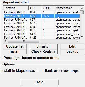
Also you may find no errors on the "Code" field, but an empty "Mapset Name". Usually these are also really bogus entries, and if "Edit" doesn't open when you click on it. You should also Uninstall them.
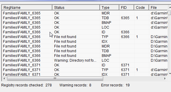
b) Afterwards do a more serious check and click on "Check Registry"
You may find more errors - for every error you find, you should identify the problematic map and either Correct it (often clicking on edit, than okay will fix it).
If you cannot fix it, then best also Uninstall the map by clicking on Uninstall.
Once "Check Registry" shows no more Warnings or Errors - your fine. Below Screenshot shows still loads of errors - and you should Delete "Family_6366" from the entries in the right hand side menu (step a) ):
4. Install maps using MapsetToolkit:
a) "Select IMG" - select all map images (.img): (choose the folder you extracted the maps to). Then click on "Select All" and on the right side click "Add". Now the mapnames should show up on the right and lift window 
b) "Select mapset directory" (this should be the directory to which you extracted the maps, but you can choose any directory).
c) "Mapset Name" - give the mapset a name - this name will show in Mapsource to select the map i.e. openmtbmap_at
d) "Family ID" - set any number between 100 and 9999. It should not be used already (check looking through the "FID" field on the right of the main window) - i.e. 6366
e) Select .TYP file.

f) Tick both options "Install in mapsource" and "blank Overview maps"

g) Controll Everything - then Click on "Start"

Here is the full view before clicking on start. Note there might be a warning shown, or error, but using cgpsmapper 097 it should nevertheless install correctly.


Leave a Reply
You must be logged in to post a comment.