Oregon:
(Classic layout)
(Wide layout)

Nüvi 200:
Gpsmap 62
Da das Display des 62er eine sehr geringe Auflösung hat, erscheinen die Screenshots deutlich kleiner wie am GPS selber. (mit "thin" Layout)
Vista HCx
Mit "thin" Layout. Allerdings empfehle ich das "classic" Layout mit dickeren Straßen, fürs mtbiken.
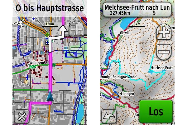
Eine komplette Zoomstrecke herein nach Wien von 5km auf 50m. Details "normal". Ausserstädtisch wirkt die Karte nicht so überfrachtet wie hier von 2km bis 500m.
Beim "fahren" am Bike, benutzt man im Prinzip aber eh nur 120 bis 50m. Die anderen Auflösungen sind primär für die Übersicht. 200m und 300m macht am Land teils noch Sinn.
Hier ein paar Beispiele vom Berechnen einer Route und dem nachfahren der Route.
In witch manner I can see the surface features also with openmtb map on etrex? (see etrex openmtb map screenshot)
I think you got mixed up. There is no way to install the VeloMap without contourlines but with buildings – except if you downloaded the gmapsupp.img files. The OpenMTBMap always comes with buildings. Please verify.
And if you install the buildings separately as gmapsupp.img – you can activate/deactivate them independently of the map (but does not make sense for the OpenMTBMap as the buildings are always included).
Thankyou for your reply, however you can istall on the computer the VeloMap Italy without the buildings and without contourlines choising in the installation menu “Map without contourlines/buildings” and at the same time installing a separate buildings only map, then creating a gmapsupp.img file with the create_gmapsupp_img_velomap_with_mkgmap.bat that is a VeloMap with buildings but without contourlines.
I know that OpenMTBMap come with buildings, in fact I can see buildings and any other surface feature on Basemap, but installing the OpenMTBMap on GPS (I tried to install the map with three methods: creating a gmapsupp.img file with the create_gmapsupp_img_velomap_with_mkgmap.bat and copying it on the SD card of the GPS; installing the map with Basemap on the SD card in a card reader; installing the map with Basemap on the SD card inside the GPS) the result is the same: the GPS don’t visualize all the surface features of the map (buildings, rivers, lakes, etc.). I don’t understand why, because the VeloMap on GPS visualize all the surface features that are visible on Basemap.
Oh yes – with the batchfile you can (only way to do so). How did you send the OpenMTBMap? Also using the batch?
Does removing the VeloMap gmapsupp.img return the buildings to the OpenMTBMap? Deactivate all other maps and see if they appear. Or maybe try switching profiles on the OpenMTBMap. Use one without mountainbike or bicycle in the name – maybe the etrex 32x now also includes the high contrast bullshit like the Garmin Edge series?
Thank you, I had active also the OpenMTBMap of France, after the deactivation of the France map I can see now in the Italy map all the surface features of the map.
well that is very strange – the maps should not affect each other – except maybe in bordering regions… But usually everything should be white then – also no roads. Maybe that changed. The VeloMap then showed the buildings because they are transparent overlay.
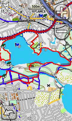
Hi, I installed the Italy openmtb map without contourlines and the Italy VeloMap with buildings but without contourlines and also the contourline map on a Etrex 32x. But whereas I see on Basecamp with the openmtb Italy map all the info of the map (see the partial screenshot of Basecamp) on the Etrex 32x with the OpenMTBMap active I see only the point and linear features (for example streets) but not the surface features (for example buildings)(see the screenshot of etrex). With the VeloMap active instead I see also the surface features (see second screenshot of etrex). In witch manner I can see also with openstreet map the surface features?
Hallo, ich habe auch das gleiche Problem mit gleichem Gerät. Die Wiesen sind blau. Die oben beschriebenen Lösungsvorschläge funktionieren bei meinem Gerät nicht. Ich habe ca. 2 Jahre die Openmtb-Karten nicht aktualisiert. Das Problem mit den blauen Wiesen ist nach dem Update der Firmware des Garmins auf die Version 8.xx (noch mit den alten Openmtb-Karten) aufgetreten. Habe die Openmtb-Karten auf den neusten Stand gebracht, das Problem besteht jedoch nach wie vor.
VG
Michael
Hallo, mein Kommentar bezog sich auf “martinspics Montag, der 20. Juli 2020 at 17:30 · Replyich”, vermutlich habe ich einen Fehler gemacht. Bezüglich der blauen Wiesen, glaube ich das Problem gefunden zu haben. Wie bereits beschrieben, ist es mit dem Garmin-Update 8.xx gekommen. Die Wiesen sind blau, wenn das Kartendesign anders als “Classic” eigestellt ist. Dabei ist es egal ob die originale “mountains.kmtf” oder Deine modifizierte verwendet wird.
Michael
In welchem Modus – im Modus high contrast oder im Modus Mountainbike? Die funktioniert nur im Mountainbike Modus – high-contrast hat eine andere kmtf die du austauschen müsstest.
aber du musst überprüfen, dass sie nicht überschrieben wird. Dies passiert neuerdings scheinbar.
In den Modis “Classic” und “mountains” sind die Wiesen grün, in den Modis “Mountain Biking” und “High Contast” sind sie blau. Welche werte müssen in den anderen kmtf Dateien geändert werden, damit die Wiesen in Verbindung mit Deinen Karten wieder grün werden?
ich nehme an die kmtf wird einfach überschrieben – bist du dir sicher dass dies nicht passiert. Denn zuvor hat diese ja funktioniert! Löschen ging früher auch – geht jetzt nicht mehr.
Ja das wird so gewesen sein, dass ich die originale “mountains.kmtf” mit Deiner überschrieben habe. Ich habe davor die “Mountain.kmtf” (die ohne “s” am Ende) gesichert und Deine Datei in den MapTHemes Ordner kopiert und vermutlich damit die originale Datei überschrieben.
bitte öffne doch die von mir heruntergeladene kmtf – und schaue ob die nicht automatisch ersetzt wird. Und du brauchst denselben Namen der da vorher war.
ich habe Deine Nachricht nicht verstanden. Die heruntergeladene kmtf mit dem Editor öffnen oder im Garmin auswählen? Wo soll ich nachschauen ob was automatisch ersetzt wird? Aber ich habe die Karte auf Classic umgestellt und komme damit gut klar..
öffne sie im editor, dann schaue dir jene am Garmin an im Editor – 100% überschrieben. die blauen wiesen sind ja ein Eintrag in der kmtf.
Hallo, Garmin Edge 530, grüne Wiesen werden blau dargestellt, s. screenshot. Ich habe beide Versionen probiert nicht/unicode, die Darstellungsdetails mehr/weniger, Karten normal/wide – es ändert nichts.
Danke im Voraus!
Martin
du musst die mountain.kmtf Datein entfernen. Oder du darfst nicht Mountain Biking als Aktivitätsprofil wählen.
im Mapthemes Ordner.
Danke, ich habe jetzt die vorigen Postings gelesen. Aber verliere ich dann die MTB Features – TrailForks, Flow, usw?
wenn du nur die Datei entfernst – dann nicht. Bezüglich Profil weiß ich nicht – ich denke kein Problem.
Also, das nenne ich “problem solution” !! Danke!! Die mountain.kmtf Datei habe ich nur aus dem Mapthemes Ordner herausgenommen, in dem übergeordneten Garmin Ordner abgelegt. Es funktioniert perfekt, kein “water world”, die blauen Wiesen sind grün. Alle MTB features sind geblieben. Echt super! Bin höchst zufrieden.
könntest du mal die folgende mountains.kmtf probieren – siehe Anhang?
Wenn die funktioniert wäre es ein Möglichkeit die einfach zu nehmen – mit dem Vorteil dass man Farbe und Dicke von Routen und Tracks adaptieren kann.
du könntest auch diesen Editor ausprobieren (ich habe einfach alles entfernt aus einem kmtf File was ich für Unsinn halte, da es besser im .typ File definiert ist. Wobei Höhenlinien könnte man evtl auch drinnen lassen – da diesbezüglich die Präferenzen auch sehr unterschiedlich sind)
Hallo, danke, hab´Deine mountains.kmtf download. Installiert/ausprobiert noch nicht, bin daweil froh, dass alles zu meiner Zufriedenheit aussieht. Ich werde später berichten.
M.
Das Ziel ist im Prinzip dass mit meiner mountain.kmtf alles gleich ausschaut – aber man halt die Möglichkeit hat Trackfarbe und Routenfarbe zu ändern (plus Höhenlinien) – ohne gleich das Typfile ändern zu müssen.
Hallo, hab´Deine mountain.kmtf installiert, die Wiesen sind grün. Aber wo kann ich die Track-Aufzeichnungsfarbe ändern?
Danke M.
Etwa hiermit: https://www.javawa.nl/zumocolors.html