Übers Autorouting
Die OpenMTBMap Karten sind zum Mtbiken und Wandern gedacht. Daher werden prinzipiell dafuer geeignete Wege gewaehlt. Straßen werden eher vermieden. Zum Autofahren muss man andere Karten fuers Autorouting benutzen. Für Trekking/Tourenradfahrer sind die Karten evtl auch benutzbar, aber ich empfehle stattdessen die deutlich geignetere VeloMap dafür.
Bergab Bevorzugung auf schwierigen Trails
Die OpenMTBMap hat eine ganz besondere Eigenschaft. Wenn ein Weg zu schwer ist ihn bergauf zu befahren, dann wird er bergauf gemieden, bergab jedoch bevorzugt. Damit dies klappen kann muss ich beim Kartenerstellen jedoch Wissen, a) wie schwer es ist bergauf zu fahren, - welches in OSM mit dem mtb:scale:uphill Tag attributiert wird -- siehe hier DE:Key:mtb:scale und b) muss klar sein in wleche Richtung ein Weg bergauf geht. Dafuer gibt es den incline tag. Wege die bergauf in OSM eingezeichnet sind, bezeichnet man mit incline=up bzw incline="positiver Wert", Wege (Wegteile) die bergab verlaufen kennzeichnet man mit incline=down bzw incline=-15 (-15 steht exemplarisch fuer 15% Gefaelle - also negativer Wert in Prozent).
Es ist also egal ob der Weg bergab oder bergauf verlaeuft, er muss nur richtig gekennzeichnet werden.
Benutzungsanleitung - Gültig für alle Programme / Garmin GPS.
Garmin hat sowohl 2012 als auch 2016 das Autorouting stark verändert. Daher muss man nun Unterscheiden, welches Garmin GPS man hat, bzw ob man Mapsource bzw Basecamp benutzt.
Prinzipiell routet Mapsource/Basecamp zuverlaessiger als die "alten" GPS wie etrex/60CSx,edge 705 und etwas besser wie Nuvis oder Oregon/Dakota.
Nur in Mapsource und alten Basecamp Versionen jedoch gibt es einen Regler der von links (kleine Straßen bevorzugen) nach rechts (Autobahnen bevorzugen) verschiebbar ist. ACHTUNG mit der OpenMTBMap ist die Richtung genau umgekehrt. Die schoeneren Wege/wenig befahrene Straßen entsprechen Autobahnen. Will man also vor allem auf gut fahrbaren Wegen geroutet werden, dann kann man den Slider nach rechts (also in Richtung Autobahnen bevorzugen - "Prefer Highways") verschieben (existiert nicht mehr in Basecamp 3.3)
Kürzere Zeit versus Kürzere Strecke
Am GPS wie auch unter Mapsource kann man obiges einstellen. Bei Schnellere Strecke versucht das GPS/Mapsource bevorzugt schoene Straßen/Wege auszuwaehlen. Dies kann jedoch zu großen Umwegen fuehren (und leider wird auch scharfes abbiegen gemieden). Besonders auf kurzen Strecken funktioniert dies sehr gut. Stellt man um auf Kuerzere Distanz wird eher versucht einen geraden Weg zu suchen - wobei jedoch noch immer Wege/Trails bevorzugt werden gegenueber Straßen.
Besonders fuer das Routen ueber groeßere Distanzen OHNE VIAPUNKTE zu setzen, ist dies empfehlenswert - da Schnellere Strecke auf laengere Distanzen nicht berechnet werden kann (Abbruch mit Fehlermeldung).
Geschätzte Ankuftszeit
Garmin GPS unterstützen keine vernünftige Berechenung der Ankunftszeit, für Radfahrer oder Fußgänger, egal mit welcher Karte. Auch werden Höhenlinien/Höhendaten (selbt mit Activity Routing und entsprechenden Karten) nicht für die Berechnung der Ankunftszeit verwendet.
Im Modus Fahrrad wird einfach ein Fixgeschwindigkeit benuttz (je nach Straße 8km/h oder 18km/h, Im Modus Fuß 4km/h. In den motorisierten Modi dagegen abhängig vom Straßentyp. Mit der OpenMTBMap macht daher die Ankunftszeit keinen Sinn. Man sollte lieber selber überlegen wie lange man für X Kilometer braucht, und Höhenunterschiede nicht vergessen.
Prozentindikator fuer Routenberechung (nur GPS)
Der Prozentindikator hat einen Bug. Er geht mindestens jede Sekunde um 1% hinauf. Dadurch kann es passieren, dass er bei 100% ankommt, aber die Route noch lange nicht zu Ende berechnet ist. Hier hilft nur warten bis entweder die Route berechnet ist, oder ein "out of memory" Fehler gemeldet wird (oder man drueckt auf Cancel/Abbruch).
Der Höhenmodus macht bei den OpenMTBMaps keinen Unterschied im Routing.
Tipp: Am besten die Route als Route mit genügend Zwischenpunkten ans GPS schicken, sowie die Funktion - "Track aus Route erstellen" unter Basecamp benutzen, und zusätzlich als Track exportieren. Dann hat man immer noch den Track - auf dem man sieht, wie die Route original ohne Neuberechnung am GPS ausgeschaut hat.
Neueste Generation: Basecamp v4.6 oder neuer, etrex 10x/20x/30x, Oregon 700/75, GPSMaps 64 aktuellste firmware/66 Serie, Edge 830/1030, Edge 820 aktuellste firmware. In etwa bei Firmwares die seit 2016 veröffentlicht wurden (und nicht nur reine Bugfixes waren).
Neue Generation (Basecamp 4.6 - 4.8)
Beachte, dass das Autorouting mit Auto/Motorrad basierten Fahrzeugen nicht mehr zuverlässig funktioniert - außer wenn man Straßen in Wohngebieten blockiert in den Einstellungen.
Normalerweise ist die beste Einstellung jetzt die Verwendung von Fahrrad, Tourrad fahren oder Mountainbike, kürzere Entfernung, und als Umgehung nur Mautstraßen und oder Unbefestigte Straßen, je nach Vorliebe für schwierige oder weniger schwierige Strecken.
Es gibt mehrere Möglichkeiten Fahrrad, Mountainbike, Tourradfahren. Mit der OpenMTBMap - wenn die Vermeidungen gleich konfiguriert sind, routen sie alle gleich. Sie sind jetzt die beste Option für längere Strecken.
Geländefahrzeug und Dirt-Biken routen ziemlich ähnlich - Dirt Biking gibt die besten Routen und kann über kürzere Strecken (<=10km per Flugzeug ohne Zwischenroutingpunkte). Allerdings ist Dirt Biking auf den meisten GPS-Geräten nicht verfügbar - während Geländefahrzeug (ATV) es ist. Für längere Entfernungen muss man zusätzlich Straßen in Wohngebieten vermeiden aktivieren.
Wandern, Spazierengehen, Bergsteigen auch alle verhalten sich gleich --> Die Ergebnisse sind für kurze Strecken mit der OpenMTBMap in Ordnung - über lange Strecken scheint sie jedoch die schlechtesten Straßen/Wege zum Radfahren zu benutzen (hauptsächlich Haupt- und Nebenstrecken).
Auto/Motorrad
nicht für längere Strecken geeignet. Sehr kurze Strecken gehen ziemlich gut. Im Allgemeinen sind ATV oder Dirt Biking jedoch besser.
Mittlere Generation: Basecamp Version 3.3 - 4.5, Dakota neueste Firmware, Oregon 600 neueste Firmware, Montana, 62er mit Firmware neuer Juni 2012. Etrex 10,20,30 ist etwas ein Sonderfall, da sie noch kein wirkliches Activity Routing unterstützen, jedoch sonst zur mittleren Generation gehören. Selbiges gilt evtl auch für das Dakota 20 mit neuester Firmware. Garmin Edge 820/520 mit original Firmware
Mittlere Generation (Basecamp 3.3 - 4.5)
Basecamp v3.3 oder neuer, sowie die Einführung von Activity Routing bei neuen Garmin GPS, haben einiges übern Kopf geworfen. Daher habe ich in vielen Stunden das Autorouting so angepasst, dass es mit alten Garmin GPS, sowie neue, und auch Basecamp/Mapsource funktioniert. Allerdings muss man die Einstellungen etwas anders wählen. Also schauen wir uns an, was was macht.
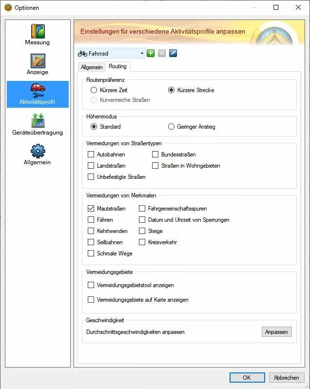
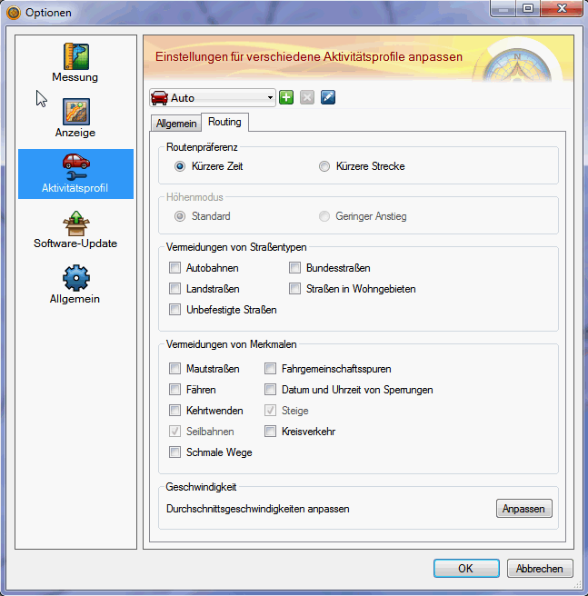
Zu den Einstellungen kommt man entweder wenn man auf eine Route rechtsklickt (gilt für die aktuelle Route), oder wenn man auf Dienstprogramme >> Optionen und dann Aktivitätsprofil klickt. Oben links im Fenster kann man das Profil einstellen. Derzeit steht es auf Auto - was das universellste Profil ist. Aber gehen wir sie durch
Auto und Motorrad Im Prinzip wird jedoch primär auf Trails, Wanderrouten, MTBRouten, und etwas abgeschwächt auch Fahrradrouten, sowie niederrangigen Straßen (tertiary) geroutet. Beide Profile, sind bei identischen Vermeidungen ident. Auto und Motorrad waren mit Firmwares aus den Jahren 2012 und 2013 sowie Basecamp v3.3 bis 4.0 das beste Profil. Mit neueren Basecamp v4 Versionen und Firmwares aus Ende 2014 und 2015 oder neuer - funktionieren es nur noch auf sehr kurze Distanzen. Dieses Profil wird daher NICHT mehr empfohlen.
Dann gibt es in Basecamp drei Fahradprofile: Fahrrad, Tourradfahren, Mountainbike - Alle drei verhalten sich bei gleichen Vermeidungen identisch. Für die kürzeste Strecke, bzw auch mal über größere Straßen, funktionieren die Profile recht gut.
Geländefahrung (ATV) und Dirt-Biken waren früher identisch - inzwischen ist Dirt-Biken das klar beste Autoroutingprofil in Basecamp bzw auf Geräten wo es auswählbar ist - es wählt etwas bessere Wege als Geländefahrung (ATV). Selbst lange Strecken >100km können meist ohne Zwischenpunkt in Basecamp wie auch auf modernen/performanten GPS (Oregon 600/650 oder neue Montana) geroutet werden. Wenn Dirt Biken nicht verfügbar ist - sollte man ATV/Geländefahrung als Modus auswählen. In Basecamp wählt man Dirt-Biken - wenn man etwa Tracks schnell erstellen möchte (Route per Rechtsklick als Track kopieren) bzw Geländefahrung (ATV) wenn man die Route etwa zum Oregon senden möchte.
zu Fuß, Wandern, Bergsteigen sind derzeit alle identisch --> über kurze Distanzen ist das Autorouting recht okay. Über längere Strecken, werden jedoch mehr oder weniger nur große Straßen, oder schlecht geieignete Straßen gewählt. Dies sind die Einzigen Profile wo schwierige Klettersteige routingfähig sind - daher zum Bergsteigen durchaus eine Option wenn man Klettersteige miteinplant.
So - welche der obigen Einstellungen macht also Sinn?
Für Crosscountry MTB: Profil Dirt-Biken bzw Geländefahrzeug (ATV) (auf GPS Geräten wie etrex 10/20/ 30 wo nicht verfügbar wählt man am besten Fahrrad) . Vermeide auf jeden Fall Mautstraßen, je nach Belieben auch noch "unbefestigte Wege" um mittelschweren Singletrails aus dem Weg zu gehen. Dazu am besten kürzere Zeit.
Für AllMountain oder Enduro: Profil Dirt-Biken bzw Geländefahrzeug (ATV) (auf GPS Geräten wie etrex 10/20/30 am besten Auto/PKW). Vermeide Mautstraßen wenn du nicht tragen möchtest. Benutze kürzere Zeit.
Für Vertriden oder technisches Endurofahren: Profil Dirt-Biken bzw Geländefahrzeug (ATV) (auf GPS Geräten wie etrex 10/20/30 am besten Auto/PKW). Keine Vermeidungen auswählen (bzw wenn dann nur "vermeide Straßen in Wohngebieten". Dazu kürzere Strecke.
Für Wandern: Profil Dirt-Biken bzw Geländefahrzeug (ATV) (auf GPS Geräten wie etrex 10/20/30 am besten Auto/PKW). Keine Vermeidungen auswählen (bzw wenn dann nur "vermeide Straßen in Wohngebieten". Dazu kürzere Strecke.
Für Bergsteigen mit schwierigen Klettersteigen: Profil Dirt-Biken bzw Geländefahrzeug (ATV) (auf GPS Geräten wie etrex 10/20/30 am besten Auto/PKW). Keine Vermeidungen auswählen. Dazu kürzere Strecke.
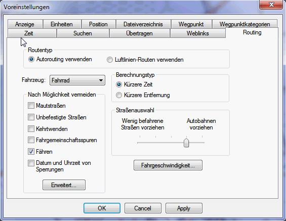
Alte Generation: Mapsource, Basecamp 1, 2 und 3.1 sowie 3.2, Alle Garmin GPS die noch kein Activity Routing unterstützen (etrex vista/legend/summit, edge 705, GPS Maps 60 Serie, Sowie auch Dakota, erste Generation Oregon, Montana, 62er Serie, und andere mit Firmware von 2011 oder älter). Achtung, nur Mapsource 6.16.3 ist voll kompatibel (außer Höhenlinien) mit den OpenMTBmaps. Auch Basecamp v1 oder v2 sollten auch nicht verwendet werden.
Nuvi, Zumo oder andere zum PKW Sektor gehörende GPS, kann ich nicht einordnen.
Alte Generation (Mapsource, Garmin GPS OHNE Activity Routing)
Transport Modes - Fahrzeugauswahl
Auto/Motorrad Funktioniert gut über kürzere Distanzen. Kann auf langen Strecken ohne Zwischenpunkt, aber für größere Umwege sorgen.
Taxi = ident zu Auto/Motorrad
Bus / LKW - funktioniert zusammen mit OpenmtbMaps ueberhaupt nicht. Es wird versucht kaum abzubiegen, was also komplett danebengeht.
Fußgänger - Kein Autorouting ueber laengere Strecken moeglich. Ignoriert mehr oder weniger die Klassifizierung von Straßen/Wegen und sucht den kuerzesten Weg.
Fahrrad = Funktioniert ganz gut in Kombination mit "kürzere Strecke". Ist gut zum Berechnen längerer Distanzen, wenn das GPS "out of memory" Fehler beim berechnen der Route produziert.
So - welche der obigen Einstellungen macht also Sinn?
Crosscountry: Fahrzeug Auto/Motorrad. Vermeide auf jeden Fall Mautstraßen. Vermeide evtl unbefestigte Straßen. Benutze kürzere Zeit
Allmountain/Enduro: Fahrzeug Auto/Motorrad. Vermeide Mautstraßen. Benutze kürzere Zeit.
Vertriding / technisches Fahren: Profil Auto/Motorrad. Keine Vermeidungen, außer evtl "Straßen in Wohngebieten". Benutze kürzere Strecke.
Vermeidung von Straßentypen
Autobahnen: Auf keinen Fall vermeiden. Sonst lässt du die besten Trails aus.
Bundesstraßen: Bitte auf keinen Fall vermeiden. Mit dieser Kategorie, würden sonst fast alle Fahrradwege, und niederrangigen Straßen, oder Wege mit guter Oberfläche rausfliegen.
Landstraßen: Nie aktivieren, der Großteil der Straßen und Wege in der OpenMTBMap ist so klassifiziert.
Straßen in Wohngebieten: Wenn man dies aktiviert, werden Primaries und Secondaries in den meisten Fällen fürs Routing gesperrt, sowie "highway=residential" also echte Straßen in Wohngebieten, oder Straßen/Wege die zum biken nicht gut geeignet sind. Da sämtliche dieser Straßen eh ein niedrige Priorität haben, macht das ausschließen wenig Sinn.
Unbefestigte Straßen: Wenn du XC fährst - also ein CrossCountry Biker bist, dann aktivier diese Vermeidung. So entgehst du schweren Singletrails, und wirst über leichte Singletrails und Forstautobahnen geroutet....
Vermeidung von Merkmalen:
Mautstraßen: Wege die primär für Vertrider sind, oder schwere Uphills, oder Wege auf denen man nicht gerne biked, bzw wo biken verboten ist, werden hiermit vermieden.
Fähren - Vermeidet Fähren, und Gondeln / Lifte / Autoverladezüge die Fahrräder mitnehmen.
Kehrtwenden - Schließt enge Kurven vom Routing aus. Nie aktivieren!
Seilbahnen: ohne Funktion mit OpenMTBMaps (am besten daher nicht aktivieren)
Schmale Wege: ohne Funktion mit OpenMTBMaps (am besten daher nicht aktivieren)
Fahrgemeinschaftsspuren: Wenn aktiviert (und dies ist Standard in allen Modi außer Auto/Motorrad), dann wird nicht über Wege geroutet, auf denen Fahrradfahren verboten ist (aber evtl praktisch).
Datum und Uhrzeit von Sperrungen - ohne Funktion mit OpenMTBMaps (am besten daher nicht aktivieren)
Steige: ohne Funktion mit OpenMTBMaps (am besten daher nicht aktivieren)
Kreisverkehre: Macht genau was es sagt. Es schließt alle Kreisverkehre aus. Sollte daher also nie aktiviert werden.
Routenberechnungsfehler
Leider ist die Berechungsmethode die Garmin benutzt, primaer fuer Routing vom Ort zur Autobahn/Schnellstraße - auf Autobahn Schnellstraße zum Zielort, und wieder kurz ueber Ortsstraßen zum Ziel optimiert. Der Routingalgorhytmus versucht so selten wie moeglich abzubiegen, und wenn er abbiegen muss, dann moeglichst ohne große Richtungsaenderung. Daher funktionieren lange Routen auf einmal berechnet nicht. Abhilfe schafft hier, dass man Viapunkte setzt - denn ueber kuerzere Strecken (zaehlen tut hier nicht die Distanz an sich, sondern die Anzahl an Abbiegevorgaengen), funktioniert das Routing recht gut (und besser als mit OpenMTBMaps wird man es nicht hinbekommen - solange Garmin nicht einen neuen Algorythmus verwendet).
Je besser/dichter eine Region gemapped ist, desto schwieriger ist es folglich auch die Route zu berechnen. Es gibt ein paar Moeglichkeiten um OHNE Viapunkte laengere Routen zu berechnen. Ersten von PKW das Fahrzeug auf Fahrrad umstellen. Und Zweitens von Schnellere Strecke auf Kuerzere Distanz. Drittens Routenberechnungsmethode zu wechseln. Und Viertens, "Unbefestigte Wege vermeiden" deaktivieren, da evtl ein paar ganz kleine Abschnitte hier fuer große Umwege verantwortlich sind (etwa weil in OSM etwas falsch/nicht ausreichend getagged ist). Ausserdem muessen von Mapsource ans GPS gesandte Routen am GPS neu berechnet werden. Dazu unten mehr
Achtung Kartenversion:
Die Kartenversion mit der die Route am PC geplant wird, muss ident zur Karte sein die du am Garmin GPS Gerät nutzt. Das bedeutet selbes Kartenerstelldatum! Und auch selbes Land (wobei das wenn es nicht über Grenzen geht meist egal ist). Also Karten am PC und am Gerät immer gleichzeitig updaten - wenn du Routen am PC planst. Für Tracks ist dies natürlich egal.
Weitere Gruende warum das Autorouting nicht auf laengere Strecken funktioniert:
1. Sehr haeufig sind in OSM leider Straßen nicht verbunden, dies zerstoert natuerlich die beste Berechnungsmethode. 2. Zu wenig fuers Fahrradfahren geieignete Straßen, aber viele ungeeignete. Besonders innerhalb von Großstaedten tut sich das Autorouting schwerer. Da etwa auch Ampeln beachtet werden und zu einer Abwertung einer Straße fuehren. Loesung: Zusätzlich Via-Punkte
Wie man trotzdem ueber laengere Strecken Routen am PC plant die das GPS neuberechnen kann:
Da das GPS die von Mapsource gesandten Routen neu berechnen muss, ist es erforderlich dies dem GPS leichter zu machen. Dies geht etwa indem man alle 1-2 km einen Viapunkt setzt. oder aber indem man die Route so plant in Mapsource / Basecamp wie man will, und vor dem senden ans GPS intelligent WinGDB Viapunkte hinzufuegen laesst. Dann entspricht auch die berechnete Strecke von Mapsource fast 1:1 der Neuberechnung am GPS. Mit der hier erklaerten Anleitung Routen effektiv planen, kann man auch mal locker 200-400km Strecke in eine Route integrieren, und die GPS koennen sie ohne Probleme neuberechnen. Auch kann WinGDB eine Route in einen Track umwandeln (oder umgekehrt) falls man lieber mit Tracks arbeitet - aber zur Planung den Komfort des Autoroutings am PC genießen will.

Hello, first of all thanks for very nice maps.
I was trying autorouting in openmtb maps, that I was planning to use on gravel rides in my Edge 1050. However, no matter if I create course in Edge directly or in Basecamp, it’s trying to navigate me through bunch of stairs in my area (in OSM it’s marked as steps). I’ve tried multiple profiles, e.g. bike touring and it’s still navigating through that. Do you know what am I doing wrong in this case? Thank you
The problem is if I forbit steps – they may make it impossible to route along some ways where it’s a short section only. There is no intelligent don’t use steps if it’s only a short way around kind of feature in garmin maps. On the VeloMap if you activate avoid toll roads and avoid unpaved roads they should be avoided. In the openmtbmap they have low priority but especially for short sections that doesn’t matter much and Garmin will still route over it.
I see, thanks for explanation. I’ll try Velomaps for this case.
Hallo, was ist die richtige Einstellung für in-device Routing mit openMTB Karten bei einem Oregon 700? Der Logik nach (“mit der OpenMTBMap ist die Richtung genau umgekehrt”) müsste dann als Aktivität statt “Mountainbike” eher “Autofahrt” ausgewählt werden, wenn man auf schönen Trails fahren möchte….?
Die Einstellungen oben unter neueste Generation. Auto funktioniert wahrscheinlich nur für recht kurze Strecken. Am wichtigsten ist die Vermeidungen korrekt zu setzen laut Anleitung.
Hi,
Thank you very much for the maps and help us.
I’d like to know what’s the difference between Walking
, Hiking or Mountaineering.
In my examples, the shortest distance is using the pedestrian activity. However, if I choose hiking or mountaineering the distance is almost equal to car taxes.
What could be the reasong?
Thanks
They are identical except by default different avoidances: https://openmtbmap.org/about-2/autorouting/
So please read through the above and adjust accordingly.
Thank you! I’ve a GPSMAP 65s and I didn’t know I could modify its activities from Basecamp. I will try it!
No you need to modify in both Basecamp and on your device. Basecamp cannot alter your GPS device settings!
Thank you.
Do you know where I could find the reason why GPSMAP 65s get different route between Pedestrian walking and Mountaineering?
While in Basecamp, with the same avoidance options I get the same route, in the GPSMAP I get a longer route with Mountaineering than Walking.
It seems like in case of the GPSMAP, in a Mountaineering activity doesn’t matter extend a few more meters to avoid some part with pavement road. Could this be the reason?
Regards
I am not sure – on the older units removing all avoidances in each profile made them identical. I wonder if/why this doesn’t work anymore.
Vielleicht hilft das ja jemandem: Ich habe gerade stundenlang versucht auf einem Edge 830 (v 9.30, 9.40) eine 6km lange Strecke mit der omtb Alps routen zu lassen. (Fast – s.u.) egal mit welchen Routingeinstellungen (Fahrzeugtyp, Vermeidungen etc.) wurde ich IMMER auf Hauptstraßen geroutet, obwohl direkt daneben ein Radweg verläuft. Unterwegs wurde ich auch immer aufgefordert, auf die Hauptstraße zu wechseln.
Ich habe dann später in Basecamp (Mac) versucht, das ganze nachzuvollziehen, und aufgrund der schnelleren Testmöglichkeiten hab ich’s dann gefunden:
– Bei Routing “Distanz minimieren” werde ich sowohl in Basecamp, als auch auf dem Edge 830 auf die Autostraßen geroutet.
– Bei Routing “Zeit minimieren” werde ich dagegen sowohl in Basecamp, als auch auf dem Edge 830 wie erwartet (und erhofft) auf Radwege und vernünftige Strecke abseits der Hauptstraße geroutet.
Zusammenfassung: Wenn ihr Probleme mit dem in-device, ad-hoc-Routing in eurem Garmin Edge 830 habt, es auf jeden Fall noch mit der Option “Zeit minimieren” probieren, welche man hier findet:
[Edge 830] = > Aktivitätsprofile > [gewünschtes Profil] > Navigation > Routing > Rechenmethode > Zeit minimieren
Vielleicht hilft das ja jemandem.
Grüße, Christian
Ja das kann passieren wenn die Hauptstraße sehr geradeausgeht – wenig Kreuzungen hat – und der Weg daneben halt deutlich komplizierter. Zeit Minimieren hat das Problem dass es meist über längere Distanzen nicht klappt.
Hi, this weekend I was about to go crazy with my Garmin while mountain biking.
I set up my Edge 830 as you say in this guide but it kept pointing me to follow the paved road instead of the mountain bike trails.
The settings were:
– vehicle type: mountain bike
– route preference: minimize ascent
– items to avoid: toll roads.
So, when I got home, I tried to plot the route with BaseCamp and in fact it gave me the same indications, which I post in the image below.
Next, I tried playing with the autorouting settings, and if I turn off state highways, it gives me the route I eventually followed (it was a route designed for a local event).
The result remains the same if I choose the car as the autorouting profile. What do you recommend me to do? Keep car as my profile while mountain biking?
Many thanks and keep up with the great work!
Emanuele
Wrong path:
Right path (both with ‘mountain bike’ + ‘avoid state highways’ and ‘car’:
avoid toll roads only if you want to avoid very difficult ways. However usually nowadays shorter distance gives better results than faster time (which you were using). Sometimes it is not possible to understand why a certain road is chosen, but mountainbike, no avoidances (toll roads does what it does usually – meaning nothing mtb:scale=3 or more difficult) and shorter distance works best. Sometimes you still have to force the route via via points.
using shorter distance or faster time didn’t make any difference, the annoying part of this is that the device was pointing me to the paved road including a 200m climb instead of a downhill single trail. Also, on garmin edge 830 you have to choose between faster time, shortest distance or minimum ascent, so it’s a bit different than the basecamp profile. I think I’ll try car profile next time
usually shorter distance or faster time makes a huge difference in the routes chosen. But yeah in some places no clue why routes do not chose a specific way.
Actually, before the big update in late May, the maps worked great and the device was directing me to nice trails.
I don’t know if this is a coincidence or if it is related to the update, or the fact that I was near a map boundary, or due to some map issue in that area.
Next time I’ll test out 🙂
Hi Felix
I found another “crash point” with the 02/07 maps, which did not happen before but now, ridden twice crashed twice. Edge 830 is being a painnful thing
It is at the point highlighted in the attached screenshot.
Closest OSM node: https://www.openstreetmap.org/node/415767820
At OSM way: https://www.openstreetmap.org/way/35444777 towards the North
I was following a route, imported into the Garmin from Komooth
Same crash at the same point yesterday with the 09/07 map.
New crash this morning at another point. Let’s see tomorrow there
Just reviewed a few past activities in Strava and the new crash is not actually new, it’s recurrent.
Closest node: https://www.openstreetmap.org/node/1847483899
Riding https://www.openstreetmap.org/way/174005252 towards the South
In both cases, the device crashes only when following a route.
I just tried it out on my Oregon 600 – however with the map from the 9. July – and it is not crashing. Can you try the 09.07 spain map please?
Yes, I did…
However I made a third pass over that point and did not crash. The only difference was that Climb Pro was off on that time
Crash today at the same point. Climbpro activated. Turn by turn guide on. Device on data screen
Made a second pass and crashed again.
Third pass with Climb pro off (but device on the map screen) and did not crash
Okay – I don’t have a device with climbpro to test. I didn’t think so far elevation profile has something to do with routing (garmins own maps work a bit differently there) – but so with climbpro it seems they do. I cannot debut this. I think it is rather due to the altitude profile than to the map itself.
I think it is finally fixed – download the maps as of yesterday/today and I hope those errors are gone.
Hi Felix
The gap in the route is gone with the latest version.
Unfortunately I am away from home for a few weeks si I won’t be able to test if the crash is gone as well.
I’ll let you know as soon as I can.
Thanks
cv
It should be gone – as well as routing problems in other areas. There was a problem with the map compiler.