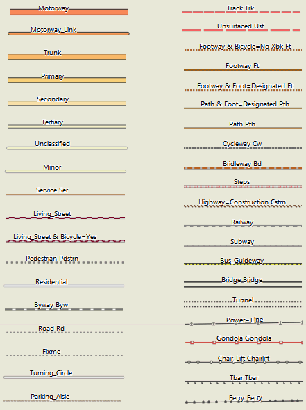
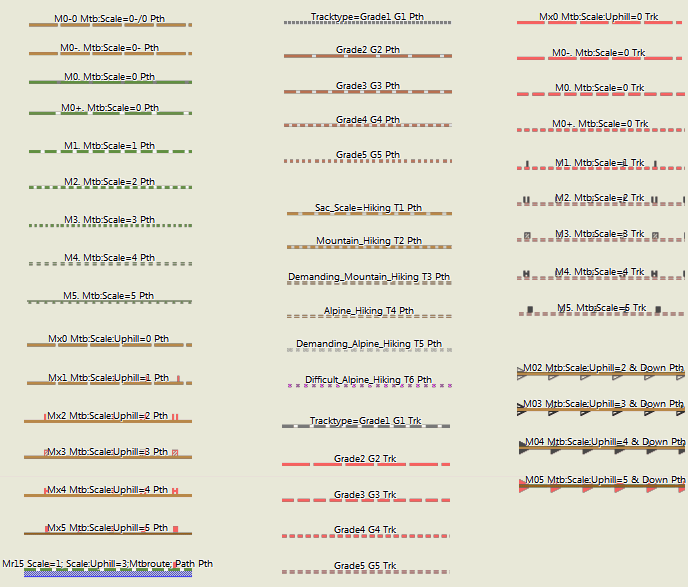
Spiegazione: Ci sono in totale 4 modelli di visualizzazione. Tuttavia le colorazioni sono sempre le stesse per "thin", "wide" and "clas". Si differenziano solamente per lo spessore delle linee per adattarsi al meglio ai differenti GPS. Il layout mapsource/Qlandkarte GT (d'ora in avanti "trad") invece ha colori differenti, con meno contrasto. Di conseguenza in questa legenda per le polilinee (Strade) ci sono sempre 2 esempi. Uno che utilizza il layout "trad" (in alto), e uno usando il layout "clas" sotto). Si prega di notare, visto che questa domanda salta fuori spesso, che vengono prese in considerazione molte variabili come il tracktype, smoothness o surface. Se volete conoscere la chiave principale che ne regola la rappresentazione siete pregati di leggere il codice sorgente dei fogli di stile (vedi FAQ). I sentieri con attributi riferiti alla mtb o alla sac_scale (clicca l'immagine per ingrandire) Linee e strade aggiuntive (clicca l'immagine per ingrandire) Ristoranti e Negozi Sport e Turismo Municipali ed altri POI Uso del terreno: Sport e Luoghi Pubblici: Natura e Turismo M12 / Mn34 -- il primo numero indica il mtb:scale, il secondo numero il mtb:scale:uphill. "n" indica una strada che fa parte di una percorso mtb. Vedere:http://wiki.openstreetmap.org/wiki/Key:mtb:scale Tv6=Trail_Visibility (6=no, 5=horrible,4=bad,3=intermediate) https://wiki.openstreetmap.org/wiki/Key:trail_visibility Xbk --bicycle=no Bicicletta Vietata Routes Differentiated by importance as follows (for Mountain Bike Routes as example) - if classified. If not it`s simply Mr. Rmn34 would be = Regional Mountainbike Route, mtb:scale=3, mtb:scale:uphill=4 Lmn3. = Local Mountain Bike Route, mtb:scale=3, mtb:scale:uphill=unknown. Highway: Vedere: http://wiki.openstreetmap.org/wiki/Key:highway Pri=primary / primary_link Cyclelane/Cycletrack Vedere: http://wiki.openstreetmap.org/wiki/Key:cycleway Bklane=cycleway=lane
Le OpenMTBMaps e VeloMaps sono fornite con diversi layout/stili (conosciuti anche come file .typ) Ci sono tre categorie principali: a) i layout di default - Classic/Classic_Legacy/Wide/Wide_Legacy/Easy/Hiking/Winter/Fenix I layouts legacy hanno i colori dell'autostrada tedesca (blu/verde/rosso/giallo/bianco) mentre gli altri layouts colorano le strade da arancione/giallo a bianco in modo simile a google maps. Sono tutti ad alto contrasto perché sono destinati ad essere utilizzati su piccoli schermi e con vari livelli di sole/ombra. Su un display di dimensioni desktop/laptop non hanno un aspetto così bello - ma permettono una distinzione molto rapida tra tipi di strade o percorsi. b) Il layout desktop - (trad/trdn) Questo è un layout a basso contrasto da usare solo su desktop/laptop - sul tuo dispositivo GPS il contrasto più basso lo renderà più difficile da leggere (utile solo se vuoi avere un contrasto migliore per le tracce o i percorsi) Di seguito gli screenshot di tutti i layout su un desktop per mostrare la differenza: Il layout classico. L'unica differenza con il layout largo è le strade più sottili. Ottimale per i dispositivi garmin con DPI più bassi. Classic Legacy - notare i diversi colori delle strade principali/autostrade. Il layout Wide - come il classico ma tutte le linee sono più larghe - per dispositivi con DPI più alti Wide Legacy - di nuovo diversi colori della strada principale Il layout facile / easy Layout - non include cose come piste ciclabili che corrono parallelamente ad altre strade, o mtb:scale:difficoltà in salita. Per il resto è identico a Wide. Layout escursionistico / hiking Layout- maggiori dettagli sulle differenze nella schermata specifica per la MTB nella prossima sezione. I percorsi non sono colorati in base alla difficoltà della MTB, ma in base alla difficoltà dell'escursionismo. I percorsi per bici/MTB sono visualizzati in modo poco visibile, in modo da evitare i percorsi per MTB, mentre i percorsi per escursioni sono visualizzati in modo evidente. Naturalmente, non ci sono nemmeno altre informazioni specifiche per la mountain bike e la bicicletta. Il layout "Simple Topo" - Carta topografica semplice - è ulteriormente semplificato rispetto al layout Hiking/Wander e non mostra le differenze tra highway=track & tracktype=grade1 e highway=residential. I percorsi per MTB, bici e trekking sono indicati, ma in modo molto scarno. Non sono indicate cose molto specifiche come mtb:scale:uphill o piste ciclabili stradali. Il layout Desktop - i colori e le caratteristiche/oggetti sono simili a Wide ma ha molto meno contrasto. Quindi è molto più piacevole per l'occhio su un grande schermo. Tuttavia sul tuo dispositivo GPS sarà molto più difficile da leggere. Puoi usarlo se segui sempre le tracce (non i percorsi) e vuoi che risaltino di più. Il layout invernale / winter Layout - come quello facile, ma in più mostra le piste da slittino, le piste da sci nordico e così via. Le normali piste da sci sono visibili anche negli altri layout in quanto esistono tutto l'anno. Questo layout ha molte cose che sono visibili solo in inverno. Il layout Fenix - questo è qui solo per il completamento - utilizza i migliori colori per il display a 64 colori della serie Fenix 5/6/7 - tuttavia si noti che sul vostro orologio apparirà abbastanza diverso dallo screenshot qui. Le caratteristiche mostrate sono un po' ridotte in quanto la dimensione del display è molto piccola in modo da mostrare le cose più importanti solo per la mtb / ciclismo. Ha linee molto ampie Nota le linee tratteggiate che mostrano le piste di sci nordico a Ramsau am Dachstein che è famosa per lo sci nordico. Mostra anche le piste da slittino o alcune altre caratteristiche che sono visibili solo in inverno e rimosse per l'estate. Le piste da sci sono di solito ben visibili anche in estate, quindi visibili in tutti i layout openmtbmap. I punti blu per esempio sono sentieri per escursioni invernali - esistenti solo in inverno (di solito una pista battuta su un campo). Un esempio per mostrare la differenza del layout Hiking che non mostra le caratteristiche per i mtbikers per rendere la mappa più facile ma utilizzabile anche per gli escursionisti. Prima il layout ampio con tutte le caratteristiche per mtbiking ora il layout facile / easy layout un po' ridotto (notare che mancano le informazioni mtb:scale:uphill) ora il layout Escursioni / hiking layout (i percorsi di trekking sono tratteggiati in nero): OpenMTBMap Standard features layout (come sul layout Wide) - vs il layout Easy - e più tardi VeloMap inner city esempio vs il layout facile manca le frecce blu per contro pista ciclabile a senso unico sulla strada centrale. Anche le strade residenziali sono mostrate come una normale strada residenziale nel layout facile - ho lasciato fuori alcune caratteristiche non così importanti e le ho semplificate. Anche i POI sono meno visibili per i negozi e i ristoranti, ingombrando la mappa. VeloMap Wide layout - quasi identico all'interno della città al layout wide di OpenMTBMap. La grande differenza rispetto alla OpenMTBMap è che alcune strade/piazze che probabilmente non possono essere percorse in bicicletta, o che non hanno una buona superficie, sono mostrate solo in modo molto sottile. Quindi meglio per il pendolarismo/ciclismo veloce. Questo è ovviamente molto più distinto se in qualche foresta/montagna. Notate che manca anche la pista ciclabile, questo perché ho usato una vecchia mappa per questo screenshot quando la pista ciclabile non era ancora costruita/presente in Openstreetmap. Il layout VeloMap Wide Easy - lo stesso del layout OpenMTBMap Easy - ha rimosso le piste ciclabili parallele alle strade, e semplificato alcune cose come le strade vive. La VeloMap Racing / Road Bike Layout - la differenza sarà più visibile fuori dalle città al layout facile. - Nota: in precedenza non mostrava gli edifici. Li ho inclusi di nuovo perché ora è possibile rimuovere gli edifici del tutto (non installarli, o utilizzare i download gmapsupp.img invece di inviarli tramite MapInstall) Il Velo Layout - linee più sottili per dispositivi a basso DPI. Colori delle strade simili a quelli di Google Maps (anche se un po' più arancione/rosso per vedere ancora le differenze nelle dimensioni delle strade) Il Velo Legacy Layout - colori delle strade in stile tedesco per una facile differenziazione delle strade principali. Stessa larghezza di Velo. Il Velo Wide Layout - lo stesso del Velo ma strade più larghe per i dispositivi Garmin più nuovi/alto DPI Wide Easy Layout - non include le piste ciclabili o le ciclopiste che sono parallele alle strade e alcune altre per la maggior parte delle cose non importanti. Guarda più in basso nella sezione Inner City per vedere la reale differenza. Il layout Road Bike / Racing - questo lascia fuori molte cose non interessanti per un ciclista su strada per identificare più velocemente le strade utili per la bici da strada. Nota che se non vuoi gli edifici - allora lascia fuori il livello degli edifici (gli edifici aggiungono troppo disordine per la bici da strada secondo me) The Simple Topo - Semplice layout di carta topografica. È semplificata in modo da non mostrare informazioni che una normale carta topografica non mostrerebbe. Ad esempio, Highway=Track & Tracktype=grade 1 (asfalto) viene visualizzato come Highway=Residential. Autostrada=servizi è indicata allo stesso modo di autostrada=residenziale. Questa rappresentazione è la più semplice da capire e richiede un po' di tempo per abituarsi. Le piste ciclabili sono visualizzate solo in modo sottile e non sono così evidenti come in altri layout. Il Layout Desktop - Lo stesso del Wide ma con molto meno contrasto. Questo è molto più bello da guardare sui grandi schermi / desktop ma non molto utile sul tuo dispositivo GPS Garmin - tranne se vuoi che la mappa sia a basso contrasto per avere un contrasto più alto per il colore rosa delle tracce GPX. Il layout Fenix - layout fortemente ridotto e adattato ai colori per i piccoli display degli orologi Fenix 5/6/7 che possono mostrare solo 64 colori. Sembra effettivamente un po' diverso sull'orologio rispetto allo screenshot - anche se differisce molto a causa dell'angolazione/sole/luce posteriore A volte la gente mi chiede se dovrei usare OpenMTBMap o VeloMap - mettiamola in modo chiaro. Se sei un pendolare o un ciclista su strada o un ciclista amatoriale la VeloMap è molto più veloce e più facile da leggere - perché ha molte meno informazioni. Qui mostro un esempio senza curve di livello e senza edifici. Se vuoi fare escursioni a piedi o in mtbike hai bisogno di più informazioni, vuoi sentieri più prominenti quindi la mappa diventa più complicata da leggere. Per il Gravel penso che in generale la OpenMTBMap sia più utile. Per la guida di una bici da trekking perché si ha spesso una cattiva qualità della superficie - ma si preferisce una buona superficie su strade di ghiaia solo non enormi strade con auto - la VeloMap sarà di solito migliore. vs il molto più semplice VeloMap - entrambi layout ampio. Nota che puoi aggiungere gli edifici e le curve di livello alla VeloMap.
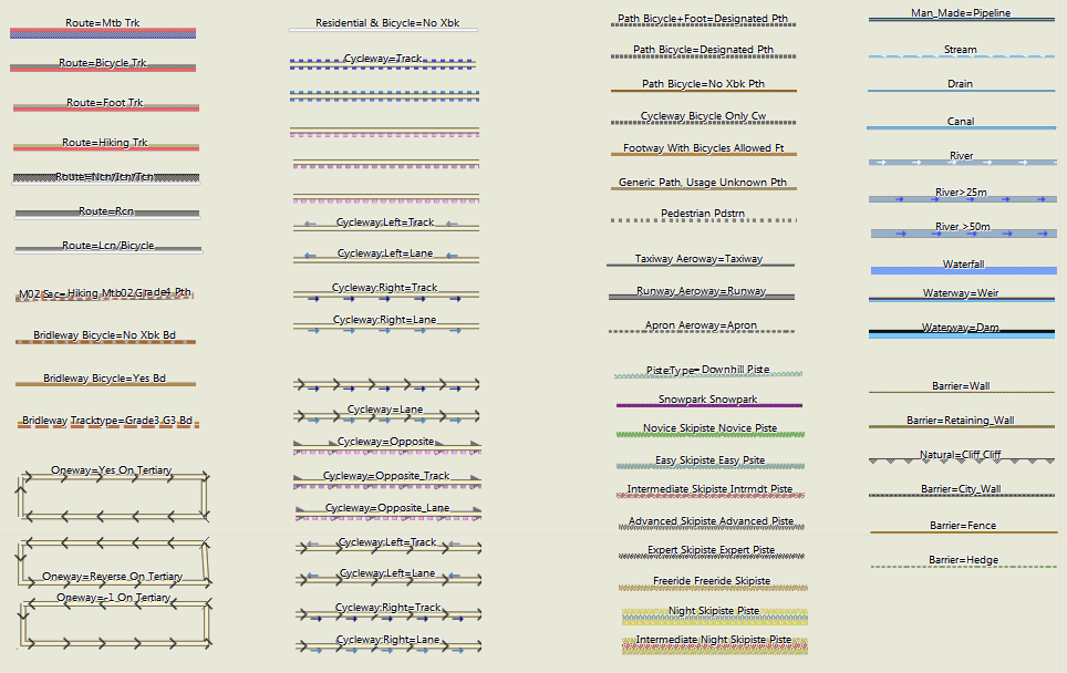
Polilinee (Highways):
Punti di Interesse

Aree
Abbreviazioni ed Attributi Strade:
G1 -- tracktype=grade1 Tipo Track= Grado1 Vedere: http://wiki.openstreetmap.org/wiki/Tracktype
T2 -- sac_scale=T2 (Escursioni in montagna) Vedere: http://wiki.openstreetmap.org/wiki/Key:sac_scale
See: http://wiki.openstreetmap.org/wiki/relation:route
Sec=secondary
Ter=tertiary
Cw=cycleway
Min=minor
Unsf=unsurfaced
Uncl=unclassified
Living=living_street
Pdstrn=pedestrian
Trk=track
Pth=path
Ft=footway
Fp=footpath
Brdlw=bridleway
Rd=road
Byw=byway
Ser=service
Bktrk - cycleway=track
Opp - cycleway=opposite
Opptrk - cycleway=opposite_track
Map Legend GeneralMap Layout/Style
Hi,
I have uploaded my MTB Sri Lanka map to my Montana 700 but all the tracks asre coloured light grey.
In Basecamp where I plan the routes they are coloured though.
What should I do? How can I get this as well on my Montana?
Thank you for helping out!
The colour information is not stored in the track. I’m not sure if there is a way to change the colour of tracks on the Montana 700. When you activte a track for routing – it will be shown more prominently. On garmin edge devices there is an xml file which can be edited that defines the colours of tracks, routes, overlays, climb pro and so on.
This is how it looks on my Montana 700. The (secondary) roads are coloured yellow, but the unpaved (MTB) tracks are all light grey / light grey dotted while in basecamp these are marked red.
Maybe there is now also a contrast mode vs classic map mode on Montana 700? Or what you see is something like climbpro?
Changing the layout of the map is done differently depending on how you send the Maps to the device. If with map install it should be very similar to Basecamp (not exactly as Basecamp does anti-aliasing which the devices cannot do usually)
ah or you mean tracks inside the map (not gpx tracks). you can change the layout of the maps – here are the different layouts: https://openmtbmap.org/about-2/map-legend/
Yes, indeed I mean the colours of tracks on the map.
I understand I can change it, I just don’t know how?
Never had this issue before, and I make use of your maps for a while already (although not an expert at all 😉
Thank you for the great work you do! 🙂
I’m super happy about being able to easily get OSM maps on my Garmin, I had given up years ago messing around with MapWel and all the workflow.
I’m curious about the trail styling though, I tried the default wide and the hiking style and there’s this weird effect making the trails much wider than they need to be, almost like there’s a drop shadow that my Garmin GPSMAP64 doesn’t properly support?
what you see in this screenshot is the indication for a mtb route (or a hiking route if that*s the hiking layout). I highlight bicycle, mtb, and hiking/foot routes like this depending on the layout.
Same issue. I updated maps after a lot of time and I found this red, really too big red shadows on a Garmin GPSMap 64. In areas with a lot of paths there red fat hilights/shadows make the display so confusing. Since now I am using a Mac I am not able to switch to a different layout. Do you have any hints to switch to a better and more readable layout?
you can also switch the layouts on Mac ´- not for gmapsupp.img files but for installed maps with Basecamp you can replace the layout. On the 64 you really should use the clas(sic) layout. The wide is too wide.
Thank you, now the lauout is again OK! 😀
Ich habe gerade nach zwei Jahren oder so mal wieder meine Karten auf meinem Oregon aktualisiert (mit den Premium gmapsupp Downloads wie immer). Dabei ist mir aufgefallen, dass jetzt plötzlich diverse Wald-/Feldwege, die vorher rot/weiß gestrichelt waren, plötzlich rot/grau oder rot/dunkelgrau gestrichelt sind… hat sich da irgendwann mal etwas geändert?
Ich fand rot gestrichelt mit weiß als Unterbrechung besser als mit grau – die grauen Unterbrechungen der roten Linien sind weit schlechter zu erkennen als weiße. Ich hab schon verschiedene TYP-Files probiert, ist aber offenbar überall genauso. Hat das einen Grund, warum das anders ist?
Ich habe vor gut 1.5 Jahren die Farben leicht geändert – damit der Unterschied der Tracktypes besser erkennbar ist.
Danke für die Antwort!
Hmm, schade – dann muss ich mir wohl eigene TYP-Files bauen. Siehe Screenshot – bei kurzem Draufschauen sind die roten unterbrochenen Feldwege kaum unterscheidbar. Als zwischen den roten Liniensegmenten weiße Unterbrechungen waren, war das sofort sichbar, ob es nun ein G2 Trk oder ein G3 Trk war (oder gepunktet dann G4 Trk usw).
Je nach GPS Gerät hat der alte Linienstil mit einer Linie außen und weiß innen bei Drehung gröbere Probleme gemacht (bei Grade 4/5 genutzt) – und die Linien sind quasi verschwunden. Daher habe ich das neue Layout eingesetzt. Dazu ist es konsistenter bezüglich sac_scale und mtb:scale Wegen.
Das Problem war zuvor das tracktype = grade 4/5 nicht gut unterscheidbar waren. Jetzt ist am Gerät der Unterschied leichter erkannbar – aber ja die Wege an sich nicht ganz so gut zu erkennen. Da gebe ich dir recht. Ist halt immer ein Kompromiss.
Hallo, bei meiner Karte von Belgien finde ich kein “Thin” Layout. Kannst du mir helfen ?
ah sorry – dass gibt es nicht mehr. Das classic bzw classic legacy layout ist dafür etwas dünner als zuvor.
Hi, danke für den Hinweis, ich versuchs mal. Muss nun die Karten nochmal downloaden. Hier tut sich bei mir die Frage auf ob ich Non Unicode Karten oder Unicode Karten laden soll.Hab das nicht so richtig verstanden…
das hängt von deinem GPS Geräte ab.
Hallo Felix,
Haber gerade auf meinem neuen MacBook mehrere Karten installiert. Nun stelle ich fest das viele Linien von Fusswegen und Radwegen sehr dick ausfallen. Hab beim Installieren nicht den mehr den Schritt gefunden wo man die Karten auf “Thin” konfiguriert. Ging das früher mal oder mach ich da was falsch ? Beste Grüße von Wilfred (ronaldlamb)
du musst in das Installationsverzeichnis und dort im Layout Folder das thin .typ-file rüberkopieren – steht im OSx Tutorial beschrieben. Auswählen beim installieren geht nur bei Windows.
Servus,
vielleicht hat jemand einen Tip für mich.
Ich arbeite mit Basecamp 4.7.4 auf Windows.
Über die Tooltips erhält man (vor allem bei hinterlegten Routen) überwiegend drei mal den Routennamen, aber keine Weginfos. (Die Legende kann ich mir im Detail nicht merken.)
Ganz selten erscheint eine 4. Zeile (siehe Beispiel).
Gibt’s eine Möglichkeit in Basecamp Wegeigenschaften zu bekommen? (Ich arbeite jetzt schon jahrelang mit Basecamp und MtB-Map, das war doch nicht schon immer so, oder?)
Martin
Da ist seit einiger Zeit ein Bug in der Namensnennung – ich muss mal schauen woran der liegt. Betrifft Wege mit Routen aber nicht Wege ohne Routen. Ich hab noch nicht rausgefunden wo da der Bug liegt – es betrifft nur Wege mit Routen – aber nicht alle.
Ich habe es jetzt korrigiert – aktuell nur Italien – aber zum nächsten Update ist es dann in allen Ländern korrigiert. Der Fehler war ziemlich arglistig und hat mich einige Stunden zum beheben gekostet.
Mit dem morgigen Update ist es dann endgültig korrigiert – war ein Haufen Arbeit das vernünftig zu optimieren – ich hatte da mal angefangen und es dann nie fertig gebracht.
You might want to update this Map Legend documentation to reflect the recent style changes. And maybe point out that you can download the “country” Legend for both velo and omtb maps, and then by varying the .typ file selection see all possible legend scenarios. And about those new lower contrast layouts: while they are more pleasing to the eye, the lack of contrast between primary and secondary highways is a major annoyance. I always liked how the old style primaries were a nice distinct red, because it is the primaries that require the most attention in planning routes. Primaries can vary from pleasant cycling roads in remote areas to terrifying bowling alleys of high speed trucks and zero-width shoulder in others. So having them red for easy, at-a-glance identification was great.
Yes I will do it in the coming weeks
Oh yeah, and most layouts also exist in legacy colours. For velomap the race layout is missing, I may add it too in future
Hallo, was bedeuten denn diese Zahlen, die in manchen Gegenden gehäuft auf der Karte zu finden sind? Ich konnte es bis jetzt nicht herausfinden.
Knotenpunkt von Radnetzwerken. google Fahrrad Knotenpunkt.
Danke!
Hallo Felix,
ich war diese Woche in der Ramsau am Dachstein unterwegs und hatte das erste Mal ein GPSmap 66s (ähnliches Display wie Oregon mit 240×400 auf 3″) mit der OpenMTB im Hiking-Stil mit dabei. Was mir aufgefallen ist, dass die Wege dicke schwarz gerasterte Streifen daneben haben. Die brauche ich eigentlich nicht und machen die Karte, wenn ich zur Übersicht für längere Routen, um etwa alternative Wege zu suchen, herauszoome, eher unübersichtlich. Weiters sind Klettersteige, die auch sehr wichtig für mich sind, im Hiking-Stil sehr ähnlich wie die normalen Wanderwege dargestellt und nicht in einer anderen Farbe (rosa im Fall von Desktop/Wide). Ist es für den Hiking-Stil möglich, die schwarzen Rasterungen neben den Wanderwegen zu entfernen oder zumindest dünner zu machen und Klettersteige in einer anderen Farbe bzw. prominenter darzustellen? Der Desktop-Stil oder der Wide-Stil ohne die MTB-Elemente würden sehr gut passen. Anbei der gleiche Kartenausschnitt aus BaseCamp in den unterschiedlichen Stilen zur Verdeutlichung. Vielen Dank und liebe Grüße, Marcus
Die schwarzen Streifen sind Wanderrouten – die sind für viele Personen sehr wichtig. Die dünnen braunen “streifen” sind MTB Routen.
Ja – die Klettersteige sollte ich ändern – da hast du Recht. Muss ich mal analysieren was da ist. Evtl haben die zusätzlich zum Via Feratta Scale auch noch eine Sac_Scale und sind daher so abgebildet (dann muss ich da eine Ausnahme machen – von der Ausnahme sozusagen).
Kann ich die schwarzen Streifen selbst irgendwie dünner machen (die MTB-Routen sind z.B. dünner)? Bin leider neu auf dem Gebiet. In manchen Regionen in bestimmten Zoom-Leveln wirds sonst etwas unübersichtlich am Gerät (siehe Screenshot vom GPSmap 66s).
wie gesagt – mit maptk –> maptk.de kannst du das gewählte Laoyut (.typ-file) bearbeiten und die Routen unsichtbar machen. Ich werde dies definitiv nicht ändern da es eine große Mehrheit (AFAIK) sehr nützlich ansieht.
Der Hias-Klettersteig ist ein Klettersteig mit Stiften in der senkrechten Wand. Ich denke, dass kein noch so guter Mountainbiker den lebendig runter schafft.
ist ab dem nächsten Update im easy und hiking Layout genauso wie in den anderen Layouts in pink.
Hi extremecarver,
I just downloaded the newest Europe-Map (non-unicode). Now there is an Area on the Map with new Symbols, which were new to me (see Attachement).
Via Openstreetmap.org I came to the conclusion, thats mayby information:guidepost.
Now I was wondering, if these knots are wrong in OSM or if its some issue with the openMTBMap, because the Symbols look a bit messy on the Map. As you can see they are visible till 1.5km-Zoom and make this fuzzy look…
Here’s one of the nodes as example: https://www.openstreetmap.org/node/8207087273
kind regards and happy easter,
Mig369
I’m gonna check this. Should not happen this way – looks like the symbol for bicycle knot points in NL.
Well I checked it now – the problem here IMHO is wrong tagging.
https://wiki.openstreetmap.org/wiki/Key:lcn_ref
Are these actually lcn_ref node points? As a quick measure I just added a rule to delete all lcn_ref & network_type=destination (don’t know what the heck that kind of network type is – as it’s not documented).
Plus in general I’ve taken out all those nodes from resolution 21 (1000/1500m) and only start showing them from resolution 22 (700m) instead. Plus for guidepost & mtb=yes/bicycle=yes I’ve changed the symbol to be less obvious. I don’t think they need to be that visible (and degraded from 23 to 24, so 200m instead of 300m).
here is another one of these: https://www.openstreetmap.org/node/275914838
Not sure how to filter that one out – network:type=node_network
Danke für die schnelle Antwort! (Hab erst nicht geblickt, dass man auch auf Deutsch schreiben kann 😉 )
Ich stecke in OSM allerdings nicht so tief drin, wenns um Relations und Netzwerke geht. Mir scheint das Tagging auf Basis dieser Anleitung gemacht worden zu sein.
https://wiki.openstreetmap.org/wiki/DE:Bicycle/Fahrradrouten_kartieren#Fahrradknotenpunktnetzwerk
Gleichzeitig scheint aber lcn_ref ja veraltet und durch die Relations abgelöst worden zu sein.
Ich habe den Ersteller der Nodes mal dazu angeschrieben, vielleicht kann er etwas dazu sagen.
Habe schon Rückmeldung vom Ersteller Karthoo erhalten:
“Hallo Mig,
Da habe ich ein neues Tagging für das MTB-Netz Hornisgrinde-Ortenau ausprobiert, da das Netz vorher in Form von nicht-existierenden Rundwegen und schrecklichen Sammelrelationen gemappt war. Zunächst hatte ich an den Routen und Knotenpunkten network:type=node_network getaggt, was ich aber mittlerweile geändert habe, da das nicht ganz korrekt ist. Ich habe dann network:type=destination angefügt, was noch nicht dokumentiert ist. An manchen Knoten, an denen auch Knotenpunkte des Wanderwegenetzes des SWV sind, ist weiterhin network:type=node_network getaggt, also bitte nicht einfach löschen.”
Vielleicht hilft das ja zum Verständnis.
Bitte schreib ihm, dass er den Tag lcn_ref entfernen soll, wenn es kein echter Knotenpunkt mit Nummer ist. Und Routen müssen einfach, auch wenn es kompliziert ist – als Relationen eingetragen werden. Und für Wanderweg Relationen gilt das genauso. Die Punkte so sind im Tagging nicht mit echten Knotenpunkten unterscheidbar – daher bitte korrigieren. Man kann Sachen etwas anders taggen – aber dann muss es klar unterscheidbar sein von bestehenden Tagging Schemata – und dass ohne neue Tags/Keys zu erfinden. Wenn dort natürlich echte Knotenpunkte sind – mit Schild auf dem die Nummer klar erkennbar ist von weitem (keine Schildnumer oder Nummer die man nur aus 1m Abstand entziffern kann) – dann ist das Tagging korrekt. Aber das scheint hier ja nicht der Fall zu sein außer ich irre mich.
Zumindest anhand dieser Auflistung gibt es in Bayern ja keine echten Knotenpunkte: https://de.wikipedia.org/wiki/Knotenpunktbezogene_Wegweisung
Der Tag lcn_ref darf aber nur dafür verwendet werden.
Ich bin jetzt etwas unsicher – es gibt in einem Teil von Baden Württemberg inzwischen wirklich ein Knotenpunktsystem – Knoten 1-70, aber ich bin ziemlich sicher eben nicht dort wo er die Knoten eingetragen hat, was ja auch in Bayern ist.
Das Problem dabei – wer / wieso auch immer hat beschlossen diese Routen als rcn einzutragen – was sie meiner Meinung nach definitiv nicht sind. Ich hab die jetzt zu lcn degradiert – was aber ziemlich kompliziert war.
hmm, technisch kann ich zwar nicht mehr weiterhelfen, bei meiner nächsten Runde mit dem Rad baue ich aber mal ein paar der Punkte ein und schau mir die Wegweiser mal in natura an.
Anbei ein Beispielbild, die Knotennummern sind auf den MTB-Wegweisern zu finden.
Hmm, dass sieht für mich nicht wirklich nach einem Knotenpunkt aus. Zumindest absolut nicht im Vergleich zu anderen Gegenden mit Knotenpunktsystem.
I am using the maps also for hiking. I was wondering if it is possible to include way markers (Wegmarkierungen) like a red diamond or red circle in the layout?
Hi Maiksen – no I cannot include them. It would need to many line types – but there aren’t than many free line types. And including them as a POI I find it not optimal either. I don’t feel Garmin map format is made for it.
[edit] – die Darstellung liegt wohl daran, dass bei “fine_gravel” die graue Linie vom Radweg dargestellt wird, bei “compacted” das ursprünglich gewohnte braun.
Bei compacted gehe ich in etwa von tracktype=grade 3 aus – daher braun. Bei fine_gravel von grade1 (nur falls keine anderen Werte da sind – wie smoothness oder tracktype).
sieht so aus als wären die Linien für cycleway and footway durcheinander geraten. Designated footway mit cycling=yes wird bei mir mit grauer, unterbrochener Linie dargestellt. Vorher war’s irgendwie braun, soweit ich mich erinnere.