Sorry the downloads on this page are only for OpenMTBMap members - get a Membership here https://openmtbmap.org/support/membership/
To Try Out you can download the map of Austria (and contourlines) for free! All other maps are only for members.
- OpenMTBMap - Austria - Gmapsupp (MD5)
- VeloMap - Austria - Gmapsupp (MD5)
- Contourlines - Austria - Gmapsupp_20m (MD5)
- Contourlines - Austria - Gmapsupp_10m (MD5)
- VeloMap - Austria - Buildings (MD5)
You can also download the Desktop version of most countries for free here: https://openmtbmap.org/download/odbl/:
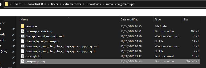
Le mappe sono disponibili in tutto il mondo tranne la mappa del continente asiatico e la mappa del continente europeo - perché sono troppo grandi. Di solito vengono aggiornate ogni venerdì. Nota - in questo modo perdi la possibilità di caricare solo una parte di una mappa sul tuo dispositivo come potresti fare usando MapInstall (o Mapsource per gli utenti Windows). Il vantaggio è che puoi cambiare il layout molto velocemente (sia su Windows, che su Mac OS x o Linux), e che è il modo più semplice e veloce. Se vuoi usare le mappe per la pianificazione sul tuo desktop - allora avrai bisogno anche della mappa Desktop o al suo posto. Nota: se pianifichi un percorso in Basecamp sul tuo desktop - dovresti usare esattamente la stessa mappa sul tuo dispositivo (quindi stessa data, stesso paese - ma Unicode/Non Unicode non importa - quindi potresti usare la mappa Non Unicode sul tuo dispositivo GPS se necessario, e la mappa Unicode sul tuo Desktop/Notebook) Video - Solo Inglese Tutti i maptiles sono compilati con mkgmap usando i dati delle mappe da openstreetmap.org & Contributors. Puoi usare e modificare i dati della mappa visitando openstreetmap.org. I dati di altitudine per le curve di livello provengono da diverse fonti nella seguente priorità (se disponibile): informazioni più precise su quali dati sono usati dove - all'interno dei file copyright.txt. Comprimere con 7-zip (lzma2) o il vostro unarchiver preferito. Evidenziato qui il gmapsupp.img che devi spostare nella cartella Garmin (non in qualsiasi sottocartella) del tuo dispositivo. Se il dispositivo accetta le schede mSD - mettetela sempre sulla SD e non nella memoria interna (solo per testare se la scheda mSD ha problemi usate quella interna) Il layout di default è "wide" - il layout ottimizzato per la maggior parte delle moderne unità GPS Garmin con DPI relativamente alti. Sposta il file gmapsupp.img nella cartella /garmin sul tuo mSD della tua unità GPS Garmin. Nota le curve di livello (linee di altitudine) sono sempre un secondo download separato - così gli aggiornamenti sono più piccoli perché le curve di livello cambiano raramente. La seconda ragione per cui le curve di livello sono un download separato è che in questo modo è possibile cambiare il layout delle curve di livello indipendentemente dal layout della mappa. Se vuoi spostare diversi paesi sul tuo dispositivo - dovrai rinominare il file gmapsupp.img. Ad esempio, chiamatelo semplicemente mtbmap_Austria.img. Assicurati di non usare Umlaut o simboli personalizzati ("_" va bene, meglio non usare ""spazio. Solo alfabeto latino) Assicurati che la mSD della tua unità GPS Garmin sia formattata in FAT32. Altrimenti non può essere letta dal tuo dispositivo. Secondo - non dimenticare che la maggior parte dei nuovi dispositivi GPS Garmin non può leggere le mappe Unicode - quindi in questo caso per le mappe che hanno (Unicode) dopo il nome, ricorrere invece alle mappe non Unicode. Per i dispositivi molto vecchi (ad esempio Vista HCx) - è possibile avere un solo file gmapsupp.img. Presto linkerò qui uno script sia per Linux/OSx che per Windows per combinare diversi file gmapsupp.img in un singolo gmapsupp.img (o includerlo nei download) Se non hai mai usato OpenMTBMaps prima - per favore leggi l'argomento sull'Autorouting: https://openmtbmap.org/about-2/autorouting/ Legenda della mappa - guardala anche tu così puoi capire meglio il layout della mappa: https://openmtbmap.org/about-2/map-legend/ Alcune mappe sono in Unicode di default - per essere in grado di visualizzare diversi alfabeti in una mappa - per esempio cirillico e latino. Senza Unicode, solo il cirillico o il latino possono essere visualizzati (mappe non-Unicode). Tuttavia, Garmin ha disattivato l'uso delle mappe Unicode gratuite nel corso di un'errata protezione della copia nei dispositivi GPS che sono stati introdotti di recente dal 2016. I paesi dove si usa solo il latino - non sono disponibili in Unicode - quindi la Germania è sempre latin1 (Non Unicode) - ma la mappa dell'Europa è disponibile sia in Unicode che in Non Unicode. I nuovi dispositivi Garmin non possono usare mappe unicode gratuite (eccetto se si modifica il firmware) - di solito un messaggio "non può autenticare le mappe" che appare all'avvio. I seguenti dispositivi Garmin outdoor sono interessati: . devi scaricare la versione "Non Unicode" della mappa. Solo le mappe delle regioni in cui sono usati diversi script - sono in unicode. Ho elencato le mappe non unicode comunque anche unter l'intestazione unicode per comodità (in realtà solo le mappe con (unicode ) dopo il loro nome sono effettivamente in unicode. Anche la versione inglese delle mappe è disponibile solo per i paesi/regioni che non usano solo il latino. Garmin Edge x30 o più recente Garmin ha introdotto una modalità ad alto contrasto completamente rotta - che sbianca i colori delle mappe. O disabiliti la modalità ad alto contrasto nella sezione visibilità delle mappe. Oppure cancella il file \Garmin\MapThemes\Mountain.kmtf (a volte chiamato anche \Garmin\MapThemes\Mountains.kmtf ) (fai un back up se pensi di voler mai usare quella modalità. Dall'ultimo firmware di luglio 2021 è necessario abilitare la modalità classica - Profili attività, selezionare un profilo e selezionare Navigazione > Mappa > Tema mappa>Classico Classico: Questo mostra le OpenMTBMaps / VeloMaps come previsto, tuttavia i POI sono ora mostrati dal profilo Edge. Lingua e Codepage Default - Lingua locale Unicode. Tutte le etichette / nomi delle strade sono esattamente come nel tag name di OSM. Nota per ogni paese che usa il latino - il default sarà latin1 e le opzioni sotto non sono disponibili. Un'eccezione è la mappa del continente Sud America che è disponibile anche in inglese non Unicode. Per USA/Canada questa è anche l'unica opzione. Per i paesi europei che usano il latino, se vuoi la versione inglese - puoi usare la mappa del continente europeo che è disponibile in versione inglese. Unicode inglese: Se disponibile in OSM - viene usata la traduzione in inglese o in altre lingue europee. Se nessuna traduzione è disponibile in OSM, viene usata l'etichetta del nome locale. Lingua locale non Unicode: Come il default, ma invece di Unicode viene usata la codifica locale. Quindi alcuni caratteri potrebbero dover essere trascritti automaticamente nella creazione. La codepage è sempre la codepage locale di default. Lingua inglese non Unicode (sempre latin1): Se disponibile viene usata la traduzione in inglese o in altre lingue europee da OSM. Altrimenti i nomi sono trascritti in latino. Schede SD Questo non riguarda le mappe, ma in generale le unità Garmin dotate di una scheda microSD accettano solo schede SDHC - le schede SDXC non funzionano. La dimensione massima è di 32 GB e la scheda deve essere formattata con FAT32 (non exFAT). Fate attenzione alle schede da 32 GB che sono disponibili sia come SDHC che come SDXC. Le schede da 16 GB o più piccole sono sempre SDHC. È molto facile scegliere un Disposizione della mappa: Di default ho disabilitato il caricamento delle mappe per la visualizzazione in Basecamp. Tuttavia se ti piace vedere la mappa quando colleghi il dispositivo GPS o la scheda mSD al tuo computer con Basecamp aperto - puoi eseguire lo script di modifica del layout della mappa (vedi Adattare il layout della mappa sopra) - alla fine dello script ti verrà chiesto di abilitare o disabilitare la visibilità della mappa in Basecamp. Le seguenti curve di livello sono con l'equidistanza standard raccomandata di 20m. Nelle regioni montuose raccomando di usare l'equidistanza di 20m. Tuttavia, a grande richiesta, è possibile scaricare in alternativa l'equidistanza di 10m per tutti i paesi e continenti (tranne la mappa del continente asiatico - perché è troppo grande). Notate che i dati di base al di fuori dell'Europa nelle regioni montuose non sono in realtà abbastanza buoni per trarre davvero profitto dalle linee di equidistanza di 10m. Per le regioni pianeggianti, tuttavia, le linee di contorno di 10 metri in tutto il mondo possono avere senso. Ecco perché le offro per il download in tutto il mondo. In generale raccomando di non installare più di 6-8GB di mappe sul tuo dispositivo in qualsiasi momento. Dato che le curve di livello non hanno un indice degli indirizzi o dei POI, non contano per questo limite, dato che non rallentano il dispositivo come le mappe normali. Notate comunque che tutti i dispositivi Garmin hanno un limite massimo di tile di 2048 o 4096 - quindi non dimenticatelo. Le curve di livello del Sud America 10m per esempio hanno già circa 3000 tiles. Quindi è meglio esportare solo quelle che ti servono usando il download di gmapi per windows o osX e inviarle con MapInstall (questo è anche il motivo per cui non ci sono Asia gmapsupp 10m contourlines - romperebbero il limite di 4096 tile). Se rompi il limite di 2048 o 4096 tile - alcuni tile semplicemente non saranno mostrati - quali non posso dirti - è casuale. Fai molta attenzione a questo limite se scegli le linee di contorno di 10 metri per un continente - o se insisti a installare le linee di contorno di gmapsupp per il continente asiatico di 20 metri (anche queste oltre 3000 tile). Non posso dirti per i download di gmapsupp.img composti da diverse mappe gmapsupp.img quale mappa copre quale parte. È un po' casuale. Puoi comunque caricare i download gmapsupp.imd in QmapShack per vedere la copertura. German Bundeslaender 20m: France DOM-TOM 20m: For an Overview of the areas covered by the US-extracts please visit: https://openmtbmap.org/support/north-america/ Le seguenti curve di livello sono con l'equidistanza standard raccomandata di 20m. Nelle regioni di usare l'equidistanza di 10m. Tuttavia, a grande richiesta, è possibile scaricare in alternativa l'equidistanza di 10m per tutti i paesi e continenti (tranne la mappa del continente asiatico - perché è troppo grande). Notate che i dati di base al di fuori dell'Europa nelle regioni montuose non sono in realtà abbastanza buoni per trarre davvero profitto dalle linee di equidistanza di 10m. Per le regioni pianeggianti, tuttavia, le linee di contorno di 10 metri in tutto il mondo possono avere senso. Ecco perché le offro per il download in tutto il mondo. In generale raccomando di non installare più di 6-8GB di mappe sul tuo dispositivo in qualsiasi momento. Dato che le curve di livello non hanno un indice degli indirizzi o dei POI, non contano per questo limite, dato che non rallentano il dispositivo come le mappe normali. Notate comunque che tutti i dispositivi Garmin hanno un limite massimo di tile di 2048 o 4096 - quindi non dimenticatelo. Le curve di livello del Sud America 10m per esempio hanno già circa 3000 tiles. Quindi è meglio esportare solo quelle che ti servono usando il download di gmapi per windows o osX e inviarle con MapInstall (questo è anche il motivo per cui non ci sono Asia gmapsupp 10m contourlines - romperebbero il limite di 4096 tile). Se rompi il limite di 2048 o 4096 tile - alcuni tile semplicemente non saranno mostrati - quali non posso dirti - è casuale. Fai molta attenzione a questo limite se scegli le linee di contorno di 10 metri per un continente - o se insisti a installare le linee di contorno di gmapsupp per il continente asiatico di 20 metri (anche queste oltre 3000 tile). Non posso dirti per i download di gmapsupp.img composti da diverse mappe gmapsupp.img quale mappa copre quale parte. È un po' casuale. Puoi comunque caricare i download gmapsupp.imd in QmapShack per vedere la copertura. German Bundeslaender 10m: France DOM-TOM 10m: For an Overview of the areas covered by the US-extracts please visit: https://openmtbmap.org/support/north-america/ Molte persone preferiscono non vedere gli edifici usando la VeloMap nelle città. Purtroppo non posso filtrare gli edifici in base al fatto che siano in campagna o in città. Se non ti interessano gli edifici, rimuoverli rende la mappa più veloce da esplorare e fa risparmiare un po' di batteria (la differenza di velocità sarà grande sui vecchi dispositivi GPS Garmin, ma quasi impercettibile sui dispositivi GPS Garmin più recenti. Inoltre, naturalmente, se non siete interessati agli edifici - non vederli aiuta il contrasto e potete concentrarvi sulle strade. Altre persone preferiscono vedere gli edifici. Per ora ho solo spostato gli edifici in un livello separato per la VeloMap - per l'uso fuori strada / Mountainbiking in generale penso che gli edifici dovrebbero essere mostrati. Potrei creare questo livello aggiuntivo in futuro anche per le OpenMTBMap se c'è richiesta. Proprio come sopra per le curve di livello - copiate il file gmapsupp.img nella cartella Garmin sulla scheda mSD del vostro dispositivo GPS (o nella memoria interna se il vostro dispositivo non ha una scheda mSD).
In generale raccomando di non installare più di 6-8GB di mappe sul tuo dispositivo in qualsiasi momento. Dato che gli edifici non hanno un indice degli indirizzi o qualsiasi POI non contano per questo limite - dato che non rallentano il tuo dispositivo come fanno le mappe normali. Notate comunque che tutti i dispositivi Garmin hanno un limite massimo di 2048 o 4096 tile, o circa 15000 tile - quindi non dimenticatevelo. Se infrangete il limite di 2048 o 4096 tile - alcuni tile semplicemente non saranno mostrati - quali non posso dirvi - è un caso. Fai molta attenzione a questo limite se vai a scaricare le gmapsupp.img del continente Europa o Asia. L'Asia è possibile solo con le curve di livello e gli edifici su dispositivi con un limite di 15.000 tile. L'Europa probabilmente romperà presto il limite di 4096 tile. Perché dovresti scaricare le mappe in formato gmapsupp.img?
- Dati della mappa
Dati sulle curve di livello/DEM:
Installazione:
Compatibilità - Unicode vs Non Unicode (non può autenticare le mappe)
Alto contrasto: Completa cazzata da parte di Garmin - perché non sono in grado di rendere le loro mappe ad alto contrasto in primo luogo.
Mountain Biking: Fregatura completa da parte di Garmin - perché non sono in grado di rendere le loro mappe ad alto contrasto in primo luogo.Adattare il layout della mappa
Visibilità della mappa in Basecamp
Collegamento dei file gmapsupp.img per dispositivi molto vecchi
Continents Contourlines 20m:
Europe Contourlines 20m:
Africa Contourlines 20m:
Asia Contourlines 20m:
Australia-Oceania Höhenlinien:
North America Contourlines 20m:
South America Contourlines 20m:
Continents Contourlines 10m:
Europe Contourlines 10m:
Africa Contourlines 10m:
Asia Contourlines 10m:
Australia-Oceania Höhenlinien:
North America Contourlines 10m:
South America Contourlines 10m:

Hallo, die Links zum Download auf https://openmtbmap.org/de/download/gmapsupp/ funktionieren aktuell nicht.
Vielen Dank
Same issue here
fixed now. sorry broken plugin auto-update
Awesome, thanks!
Ist repariert – ein Plugin Auto-Update von WordPress hat eine kapute Version gehabt.
Hi, blöde Frage: funktioniert mit diesen Karten die climbpro Funktion im Freien fahren ohne geplanter Strecke noch? Edge 840 in diesem Fall.
Thx und LG
Auf meinem 1040, ja. Höhenlinien müssen gesendet sein.
Help please
Trying to install morocco maps on my Garmin zumo 396.
I see the map in the maps list on base camp, together with other openmtb maps I already had.
I can see the map in the zumo folder, but when i try to select it in the device itself it doesn’t show up.
On base camp if i choose the maps to be installed in the device i get the Whole list of my openmtb maps to be selected but no morocco in the list.
Thank you
You need the non Unicode version of the Morocco map.
I wiped every other map, dragged non unicode in Garmin folder, opened base camp and I see the Morocco map in the list.
But not in the installable maps on the device
Please show a screenshot of the Garmin folder. You must have the UC instead of nu map of Morocco installed
Ok dann sollte es kein Problem sein denke ich.
Ähm nur zum Verständnis was bedeutet in dem Kontext “müssen gesendet sein”?
Danke nochmal – ich probier’s die Tage auf jeden mal, diese karten erweisen mir seit Edge 800 gute Dienste und ich bleib auf jeden Fall dabei
Bei den Gmapsupp Karten sind die Höhenlinien ja nicht integriert – sprich du musst die Höhenlinienkarte seaparat herunterladen/senden. Diese beinhaltet das DEM welches für Climbpro nötig ist.
Check. Danke!
which map do i need to download for the map of aruba?
I downloaded the non unicode map, and transferred the gpsmapupp file in the Garmin folder.
Upon opening base camp it installed the map by itself in the device.
The map can be visualized in the base camp screen, but apparently it can’t be installed on the device. Am i doing something wrong?
Thank you for the fast answer
Did you remove the unicode map of Morocco before you sent the non Unicode one? Please make sure you only have the non Unicode map on the Garmin!
I wiped every other map, dragged non unicode in Garmin folder, opened base camp and I see the Morocco map in the list.
But not in the installable maps on the device
I thought you use the gmspsupp download, again you are 100% using the Unicode map instead of the non Unicode. You should not rename to gmspsupp but leave original name (it’s only super old devices that needed it to be named gmspsupp.img)
Dem map of Iraq 2025
map dem iraq 2025
Sorry, I don’t know what you mean. Every contourlines map from me has a DEM integrated. So just download the contourlines to have DEM for routes/climbpro and similar.
Please provide an updated Iraq DEM map for 2025, named Iraq_DEM_2025.
There is nothing to update. The mountains didn’t move, I have no better source of altitude information. The normal Iraq map gets updated as always…
Peace be upon you. Is there a DIME 2025 map for Iraq?
What do you mean with DIME? The map of Iraq is updated every two weeks (or better every 7 days either the English or the local Language map is updated)
Hi Felix,
I bought a new garmin device (Edge 840), which can’t use mSD, but there’s not enough space on the internal memory to upload your gmapsupp.img file because there are the original garmin maps preinstalled. Do you know which garmin map files can I remove from the internal memory in order to create enough space for the gmapsupp.img file?
Thanks
any of the detailed *.img files. Not the small ones like basemap, timezone map or whatever. Anything over 1GB should be a detailed map (likely anything over 200MB).
Hallo Felix,
lustiger Effekt: ein reload der Seite hatte keine Änderung gebracht, die Seite blieb italienisch. Aber das Schicken des vorherigen Posts hat die Seite neu geladen – inkl. meinem Post – und schon ist der Text auf deutsch.
Schöner Effekt, aber sicher nicht leicht zu finden. Ein Cache-Problem könnte schon sein, aber vermutlich eher im Server.
Schönen Gruß
Christian
Hmm, du bist der zweite dem es passiert. Es hat irgendwas mit der Umstellung auf http3/quic zu tun, aber bisher hat immer noch einmal auf die Flagge klicken ausgereicht. Das Problem ist dass es glaube ich nur sehr selten auftritt – und ich nicht herausgefunden habe wie es zu reproduzieren ist. Ich möchte ungerne wieder auf http2 zurück, da http3 deutlich Geschwindigkeitsvorteile hat.
Hallo Felix,
bei mir sind auch alle Seiten (deutsch, englisch, italienisch) auf italienisch.
Aus dem Cache kann das bei mir nicht sein, weil ich mit meinem neuen Rechner zum ersten mal auf openmtbmap.org bin.
Das Problem dürfte also auf der Serverseite liegen.
Schönen Gruß
Christian
Hallo Felix,
wundert mich, dass ich zu Folgendem nix gefunden habe Aber wahrscheinlich bin ich nur wieder zu blöd zum Suchen.
Seit der Firmware 21.x unterstützen es die Garmin Geräte ja nicht mehr, direkt als Laufwerk verbunden zu werden. Unter MacOS gibt es meines Wissens auch keine Möglichkeit da irgendwie zu tricksen.
Muss ich jetzt immer den umständlichen Weg über Basecamp und MapInstall gehen?
Dank und Gruß
Andreas
Ich glaube ja. Ich kenne mich bei Mac OSx diesbezüglich nicht gut aus.
Nach dem Posten der Frage war wieder alles OK, sorry.
Hallo Felix, die Seite “Premium Gmapsupp.img – direttamente per le unità GPS Garmin” wird bei mir nur noch auf Italienisch angezeigt. Fehler bei mir oder auf der Seite? Viele Grüße Klaus
Ich habe vor kurzem den Server auf http3/quic geändert – ich nehme an das sind Cache Fragmente von vorher auf deinem PC.