Meet you at Lago di Garda


(note - german translation on the website as always)

Well - this time the news are not much. Over the last weeks I've been mainly bugged down by various administration tasks and only updated little things on the maps.

E.g. today I went through all of the plugins of this website and tried to replace all those that were not updated anymore - sometimes quite tedious to find proper replacements...

So actually I'm happy that summer is over - and for me now the quiter period of the year (till February) is starting...


Therefore I will be cycling 5 days at Lago di Garda starting Friday Morning till Wednesday.. Would be happy to meet up with some people - also maybe some Italians living in Trento? I know you've been mapping mtb trails around your area from my last trip. I'm open for anything from S1 to S5 (only condition singletrails downhill - but does not need to be very difficult).

If I'm riding alone I'll be outfitted with my etrex 30 on the right hand side of the handlebar, and my Oregon 600 on the left hand side - to try out map visibility, little tweaks, future changes and so on... Cannot always do this on my hometrails..


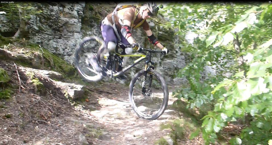
Also for the first time in my biking career - I bought a nice shiny bike, instead of assembling components onto used frames.. (well not new, it was a testbike so I got a hefty discount - but top of the line and nearly everything as new).

Here's a little scary video of my 3rd trip on it - still need some time to get used to it for the really crazy section where I'm spotting and didn't ride myself...


best quality:

short_little_italy


(better quality - needs clicking in the bottom to change from 720P to 1080P)

http://videos.mtb-news.de/38125


(lowest quality but most popular host)

https://www.youtube.com/watch?v=kyfoIVMMOPg


Just to note - at Lago di Garda I will also ride much easier stuff...

Map Updates – Recap 2…


Hallo Everyone, let's continue the news recap and also inform you about latest changes.

First off all there are new contourlines for Denmark, Norway and Finland and Sweden. They are fully based on viewfinderpanoramas.org 1" data - so very high quality. However for Sweden only the 50km bordering Norway are actually excellent quality. The rest is based on 3" data.

So good news for your next trip to Scandinavia. Hopefully soon viewfinderpanoramas.org will update the data for the Alps too - then I will of course also update the contourlines in the Alps.


Also I went through openmtbmap and velomap websites and made sure no more broken image links are present anymore. So the map legend and the screenshots are updated (lesson for me - never upload any images to image hosters - or expect them to be deleted after a couple of years).

I'm thinking of upgrading the layout of the websites end of this year - but still some time to go.


Lots of work on removing obsolete fixme=incomplete arrows in the maps. Now  it should really only be used if a highway is not fully entered in OSM database and also some more stringent requirements when fixme=continue or noexit=no are shown with arrows in the maps.


Again more work on transliteration.


Highway=unclassified was shown with highway=residential color in resolution 23. Fixed for both Openmtbmap and Velomap


Here's a screenshot of North Norway with the new contourlines (well to be frank - you won't notice on the overview- but if you zoom in then the higher quality is quite obvious).


Recap of older Changes


fix bug on unclassifieds roads that are part of mtb route and shown as track...

Another big change - especially important for well developed countries is that there is now a new layout for unpaved primary/secondary/tertiary/unclassified/residential roads. I will still optimize this a bit in the future though. However since 3 weeks it should be clear to anyone if for example a tertiary road is not paved.

I still think that the OSM key smoothness is a much better tag to indicate road condition for cycling than tracktype. Of course I convert the values to tracktype - trying to make sure that a grade1 is always paved, a grade2 is a compacted surface (e.g. good condition gravel) and so on. However I mainly relied on smoothness if available to do so. Badly though I must say I noticed much more errors on smoothness values than on tracktype values. Therefore I now treat both keys as same important - and use them much stronger for errorchecking.

Also I reworked the surface key in order to better classify tracks and trails - inocorporating many new values

OSM changed the way forests and wood are described. I therefore uncluded the new keys Leaf_cycle and Leaf_type in order to classify wood/forest/scrub. I keep on using the standard european map layout with mixed, deciduous and coniferous only though. Also for a long time natural=wood without wood=.... was omitted in resolution 21 in the maps. Fixed this.

Lots of countries got improved address search by incorporating the local rules better.

Service=high_speed for highspeed trains (plus rework of other keys that identify high speed railway lines), and better identification of big rivers/canals.

Rework of naming of peaks and summits.

All maps now have integrated contours - also Asia. So for any country (on windows) the installer will automatically install the contourlines. Long time this was not true for Asia.


Many many more fixes and changes were done.  OSM is constantly evolving, and so are tagging practices. I try my best to constantly reflect this.