About the Autorouting
The maps offered here are to be used for cycling, mtbiking and hiking. There is a general preference to route you over trails and cycleways. Streets have lower priority. However note that the GPS will not take huge detours on trails to avoid a primary or secondary highway - even though they have the lowest priority. Autorouting with my maps is unusable with a motorcar. Use another Openstreetmap implementation instead if you intend to use you car. The maps can be used for autorouting on a racing bicycle - however the Velomaps are better for racing bicycles..
Downhill preference on difficult trails
All trails from which I can assume that they are usable downhill only will have much higher priority in the downhill direction, uphill they will only be chosen if long detours are unavoidable otherwise. This means uphill on relatively easy trail, downhill much more technical. In order for this to work you need to use the incline tag correctly. I have rules setup to catch more or less any value, be it incline=up or incline=down, incline=(-)??% or also wrong tags like incline=positive or incline=-. Any way with mtb:scale:uphill=4 or mtb:scale:uphill=5 (see mtb:scale for explication of mtb:scale:uphill) will be avoided on uphill. Therefore please add mtb:scale:uphill and incline tags to all your favourite trails that are too difficult for uphill. mtb:scale:uphill=3 will be considered oneway if incline>15% or incline<-15%.
It does not matter whether the way itself in the OSM database points uphill or downhill. I reverse ways pointing uphill when rendering the maps. This is of course only possible if the incline tag exists on the way.
Usage Instructions - For All Programs / GPS.
Note that all may behave different. In principle we have the following classes:
New Generation - Basecamp v4.6 - 4.8, Oregon 700/750, GPSMaps 64 current firmware/66 series, Edge 830/1030, Edge 820 with current firmware
New Generation - Firmwares from 2016 onwards - Basecamp 4.6 or newer:
Note that long distance routing does not work reliably with car based vehicles anymore - except if you block residential roads.
Usually the best setting is now to use bicycle, Tour cycling or mountainbike or, shorter distance, and as avoidances only toll road and or unpaved roads based on preference for difficult or less difficult trails.
Then there are several Bicycling, Mountainbiking, Tour Cycling options. With the OpenMTBMap - if you configure the avoidances the same, they all route alike. They are now the best option for longer distance routing.
ATV and Dirt Biking Route pretty similar - Dirt Biking gives the best routes and can route over shorter distances (<=10km by air without any intermediary routing points). IUt usually fails on longer distances. Also Dirt Biking is not available on most GPS devices - while ATV is.
Hiking, Walking, Mountaineering also all behave alike --> The results are okay for short distances with the OpenMTBMap - over long distances however it seems to use the worst streets/ways for cycling (mainly primary and secondary roads).
Motocar/Motorcycle
not suitable for longer distances. Very short distances route pretty well. In general ATV or dirt biking are better however.
Mid Generation - Basecamp v3.3 to v4.5. Dakota, Oregon 600/650, Montana, GPSMaps 62 series with newest Firmware, 64 with older firmwares, edge 520/820 with older firmwares
Mid Generation (Basecamp 3.3 - 4.5 or older Garmin GPS with first version of Activity Routing Support)

Basecamp v3.3 to 4.5 behave quite differently to previous versions, or Mapsource, and also on the internal side of how it checks the maps, and what it does is very different. So Let's have a look on what you can set. In Principle (except for etrex 10/20/30) the GPS devices behave very similar to Basecamp v4.
In the top left, you can set the Profile. Currently Automotive is activated.
Automotive and Motorcycling have been the method of choice for Basecamp v3 and Mapsource - but are not really usable except for short distances with OpenMTBMaps in Basecamp v4 and newer anymore! On etrex and 62s series - where you cannot choose ATV as routing mode - use car or bicycle.
Then there are several Bicycling, Mountainbiking, Group Cycling (and maybe more in future) options. With the Openmtbmap - if you configure the avoidances the same, they all route alike. These modes are okay, if you don't mind to find yourself quite often on asphalt and streets. They do tend to often use bigger streets with newer firmwares though.
ATV and Dirt Biking Route pretty similar - Dirt Biking gives the best routes and can route over very long distances (>100km by air without any intermediary routing points). However Dirt Biking is not available on most GPS devices - while ATV is (e.g. on most Oregon/Montana and maybe Dakota/64s?).
Therefore you can chose between ATV - which is the best choice if you want to transfer the route itself to your new generation device - and Dirt Biking, which you can use for best routes that you copy via right-click advanced to a track - and send the track to your device (except of course if your device supports Dirt Biking profile - then go for it in any case).
Hiking, Walking, Mountaineering also all behave alike --> The results are okay for short distances with the Openmtbmaps - over long distances however it seems to use the worst streets/ways for cycling (mainly primary and secondary roads). Difficult Via Ferratas are only available in this mode!
So what of the above makes sense?
For CrossCountry: Use profile ATV/Dirt Biking, avoid toll roads, and avoid unpaved roads. Use shorter time.
For AllMountain/Enduro: Use profile ATV/Dirt Biking, avoid toll roads. Use shorter time.
For Vertriding / Technical Enduro or whatever you call it and Hiking: Use profile ATV/Dirt Biking, don't avoid any roads/features. Maybe avoid residential roads. Use shorter distance.
Hiking/Mountaineering with Via Ferrata included: Use Mountaineering mode - without any avoidance.
-- As the map data in Openstreetmap is everywhere different, and also the offer of good ways/routes for mtbiking differs a lot, just try around a bit in Basecamp, to find out what happens. In General Basecamp and your GPS will route similar over short distances.
Old Generation - Mapsource, Basecamp v1 & v2 & v3.1, v3.2, All Garmin GPS WITHOUT Activity Routing (etrex vista/legend hcx or older, edge 705, GPS Maps 60 series; AND Dakota, first generation Oregon, Montana,GPSMaps 62 series with older Firmwares )
Old Generation (Mapsource, Garmin GPS without Activity Routing Support)
Transport Modes
Car/Motorcycle = Works well on shorter distances - might produce long detours.
Taxi = behaves like Car/Motorcycle.
Bus / Truck = Avoids turning. Hence don't use it.
Pedestrian No good autorouting over longer distances, will usually give quite direct vias - does not respect oneways.
Bicycle = Works well in combination with "shorter distance". Is good for calculating longer distances on you GPS if you get "out of memory" errors.
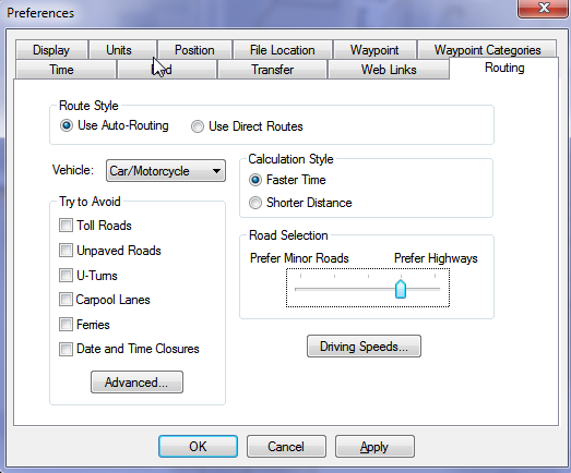
Only For Mapsource - Note the slider called "Road Selection". The more towards the right (prefer highways) you push it, the more you will be routed over great trails, hiking routes, mtb routes or cyclroutes. Never move it to the left. If you feel that cycleroutes, hiking routes, and mtb routes are favored too much, better use transport mode: bicycle, or use "shorter distance".
Only Available on (some) old Generation Garmin GPS Devices - Route Calculation Method: Per default I would advise to use "quick". However if you get "out of memory" errors, go for "better route". On best route calculation is able to get you to pretty remote places, however you might need to wait up to 10 minutes or longer until the calculation is actually finished.
Route Calculation Percentage value - The indicator has a bug on all units. It is only correct if jumping by several percent. However if it only increases by one percent per second, then it will reach 100% long before it has calculated the route. Hence when it gets stuck at 100%, there is still a good chance that the route can actually be calculated correctly. Using "better route" or "best route" for route calculation method, this often means waiting 3-5minutes until the route is actually calculated.
So what of the above makes sense?
For CrossCountry: Use profile motorcar, avoid toll roads, and avoid unpaved roads. Use shorter time.
For AllMountain/Enduro: Use profile motorcar, avoid toll roads. Use shorter time.
For Vertriding / Technical Enduro / Hiking or whatever you call it: Use profile motorcar or bicycle, don't avoid any roads/features. Use shorter distance.
Hiking/Mountaineering with Via Ferrata included: Use Pedestrian mode - without any avoidance.
For the Old Generation, there is still one Distinction. In Mapsource under options/autorouting you have a slider to prefer small roads (left side) to highways (right side). If you move this slider to the right hand side, better suited ways/streets will be preferred. On the GPS such a setting does not exist, but the GPS is anyhow more strict on choosing well suited roads. On the other hand the "route calculation method" is only available on the GPS.
Faster Time vs Shorter Distance
With my maps shorter distance already tries to route over nice ways. If you use "faster time" - especially in combination with car/motorcycle or Automotive mode, then an even higher preference for "nice" ways will be used and routes tend to be longer (more detours) overall. With my maps there is no such routing as really shortest distance (it is actually impossible to do really have autorouting on Garmin GPS find the shortest route over long distances). If you use shorter distance the route will be in general straighter and with less detours - also longer overall distances will be calculated without crashing (error notice, no actual crash).
Estimated Arrival time
Garmin is not supporting proper Arrival times for Cycling. Using bicycle the estimated arrival times using "faster time" are simply calculated by averaging 18km/h - hence not very useful. Using "shorter distance" the arrival time often becomes really bogus. Using Automotive, Car/Motorcycle or other modes, the times will be far too short. Also elevation (so climbs or downhills) are not taken into the calculation. This is the same for Garmins own maps.
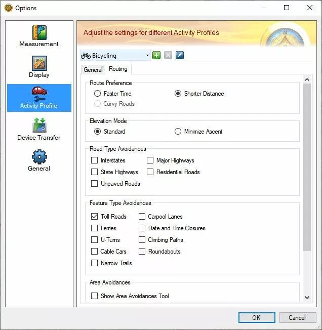
Road Type Avoidances
NEVER Tick "Avoid Highways" - It will block the best ways. On my maps, shared use pathes and cycleways are encoded for the GPS as highways. Real highways or big streets where cycling is not allowed are not routable anyhow with the Openmtbmaps (so no need to avoid them).
Interstates: don't avoid them, you'll miss the nicest trails.
Major Highways: If you tick it you will avoid streets that are nice for cycling, cycleways, cyclepaths, and so on. Well as you want to cycle with this map, I don't think you ever want to tick that box.
State Highways: Don't tick it. Most ways in the Openmtbmap would be blocked.
Residential Roads: If you tick it, then residential streets, primaries and secondaries are blocked as well as trails that are no fun to bike. May work, but don't bet on it (too often some very short residential street or bad quality trail is necessary to get from A to B without crazy alternations.
Unpaved roads: If you are a XC biker, then yes, try activating it. All ways with mtb:scale=1 or higher are blocked, as well as sac_scale = T2 or higher.
Feature Type Avoidances:
Toll roads Avoid ways, that are only for vertriders. Also avoids biking against the allowed traffic direction, blocks uphills you have to carry your bike (if mtb:scale:uphilll and incline are set properly), or ways were you are not allowed to bike.
Avoid Ferries - Avoids ferries, cablecars, gondolas and mixed lifts.
U-Turns avoids any turn over 120° - best not use, because it will destroy sensible autorouting.
Cable Cars: Does not matter with Openmtbmaps (or more correctly, does not work, best don't tick anyhow).
Narrow Trails: Does not matter with Openmtbmaps
Carpool lanes: Avoids all ways where cycling is forbidden (and no more). (is activated by default in all profiles but car/motorcycle).
Date and Time Closures - it is currently not possible with mkgmap to produce maps that react to this setting.
Climbing Paths: Does not matter with Openmtbmaps.
Roundabouts: Well does exactly what it says. I advice you to never tick this box, else roundabouts are avoided, and then routing likely won't work well.
General Tips and Advices - e.g. Route Calculation Fails
If Routing fails and you need to get somewhere without being able to set via points, you can try with “shorter distance” caculation which should autoroute even through heavily mapped cities (actually the better a region is mapped, without sufficient bicycle/mtb routes the more difficult it is for the routing engine to get over longer distances, Enabling “shorter distance” instead of “Faster Time” gets you to your destination quite well (though then also big streets are chosen quite often). Due to the way the maps are setup, setting your GPS to “shorter distance” should generate routes that are much quicker. “Faster Time” calculates nicer routes, but will take much more time. It it fails with "out of memory" error, you can also change the route calculation method. Another possibility to to deactivate "avoid unpaved roads". Often some very small patches of unpaved roads will hinder the routing to work well. Then just try to cycle a bit nearer using the route, and after a few kilometers (or better say 20 turns) click on recalculate after reactivating avoid unpaved roads.
Attention - Same Map.
You need to plan the routes with the identical map in Basecamp (same country, same date (that is paramount) that you use on your GPS device. Unicode/Non Unicode does not matter however. If you created the route with an older map - recalculate it in Basecamp first - then send it again to your GPS device. Also if you update maps on your device - it will often lead to errors if you try to use an older route (does not have to - but the more months between the map used for planning, and the map used with the route on your device - the more likely you get route calculation errors). To correct this - recalculate the routes in Basecamp with the new map - and send them again to your device. If the route now does not work in Basecamp anymore - its quick to notice. Maybe you will need to move some via points.
Routing does not work over long distances:
There are two main causes for bad routing: 1. non connected streets in OSM. 2. Not enough streets suitable for cycling - or tracks and pathes that are not tagged with tracktype/smoothness so that they are blocked when using "avoid unpaved roads". You should be able to route for 15km minimum to about 70-80km maximum without needing to route over via points on old GPS. Using Mapsource or newer GPS like Oregon or Dakota you can route over much longer distances. Very very long routes will never work because the routing engine of Garmin is not strong enough (and maybe there are still some improvements to be made in mkgmap). This is because Garmin algorithm likes to go straight for long time (like on a motorway) - routes suitable for cycling or mountainbiking make turns, have many intersections and are not so easy to be routed on. Because I don't want the maps to send you onto big roads, routing will not work over very long distances. For autorouting inside your car there are better maps available. Maps offered here are supposed to give you the best routing possible on Garmin GPS for mountainbiking / hiking or cycling. Solution: Insert additional via-points.
How to overcome problems when routing over long distances:
Routing without via points over large distances (i.e. 50-100km) will often not work, even though by setting via points you will find a way. The better the OSM Coverage the greater the distance you can cover with the autoroute function. For in car use I recommend either Garmin City Navigator maps if you have the doll to shell out, or the excellent Autoroutable maps by Lambertus: http://garmin.openstreetmap.nl/ The maps offered here are to be used for cycling, commuting via bicycle and roadbiking. I have structured the Routing Preferences so that small streets are preferred over larger streets. If you want to plan you're routes in Mapsource and be sure that recalculation works on GPS I recommend you to read through here: plan-routes-efficiently following this tutorial and using wingdb you can easily create routes via pc that go over 200-300km. I advise however to make a new route for each day.

Hallo, was ist die richtige Einstellung für in-device Routing mit openMTB Karten bei einem Oregon 700? Der Logik nach (“mit der Openmtbmap ist die Richtung genau umgekehrt”) müsste dann als Aktivität statt “Mountainbike” eher “Autofahrt” ausgewählt werden, wenn man auf schönen Trails fahren möchte….?
Die Einstellungen oben unter neueste Generation. Auto funktioniert wahrscheinlich nur für recht kurze Strecken. Am wichtigsten ist die Vermeidungen korrekt zu setzen laut Anleitung.
Hi,
Thank you very much for the maps and help us.
I’d like to know what’s the difference between Walking
, Hiking or Mountaineering.
In my examples, the shortest distance is using the pedestrian activity. However, if I choose hiking or mountaineering the distance is almost equal to car taxes.
What could be the reasong?
Thanks
They are identical except by default different avoidances: https://openmtbmap.org/about-2/autorouting/
So please read through the above and adjust accordingly.
Thank you! I’ve a GPSMAP 65s and I didn’t know I could modify its activities from Basecamp. I will try it!
No you need to modify in both Basecamp and on your device. Basecamp cannot alter your GPS device settings!
Thank you.
Do you know where I could find the reason why GPSMAP 65s get different route between Pedestrian walking and Mountaineering?
While in Basecamp, with the same avoidance options I get the same route, in the GPSMAP I get a longer route with Mountaineering than Walking.
It seems like in case of the GPSMAP, in a Mountaineering activity doesn’t matter extend a few more meters to avoid some part with pavement road. Could this be the reason?
Regards
I am not sure – on the older units removing all avoidances in each profile made them identical. I wonder if/why this doesn’t work anymore.
Vielleicht hilft das ja jemandem: Ich habe gerade stundenlang versucht auf einem Edge 830 (v 9.30, 9.40) eine 6km lange Strecke mit der omtb Alps routen zu lassen. (Fast – s.u.) egal mit welchen Routingeinstellungen (Fahrzeugtyp, Vermeidungen etc.) wurde ich IMMER auf Hauptstraßen geroutet, obwohl direkt daneben ein Radweg verläuft. Unterwegs wurde ich auch immer aufgefordert, auf die Hauptstraße zu wechseln.
Ich habe dann später in Basecamp (Mac) versucht, das ganze nachzuvollziehen, und aufgrund der schnelleren Testmöglichkeiten hab ich’s dann gefunden:
– Bei Routing “Distanz minimieren” werde ich sowohl in Basecamp, als auch auf dem Edge 830 auf die Autostraßen geroutet.
– Bei Routing “Zeit minimieren” werde ich dagegen sowohl in Basecamp, als auch auf dem Edge 830 wie erwartet (und erhofft) auf Radwege und vernünftige Strecke abseits der Hauptstraße geroutet.
Zusammenfassung: Wenn ihr Probleme mit dem in-device, ad-hoc-Routing in eurem Garmin Edge 830 habt, es auf jeden Fall noch mit der Option “Zeit minimieren” probieren, welche man hier findet:
[Edge 830] = > Aktivitätsprofile > [gewünschtes Profil] > Navigation > Routing > Rechenmethode > Zeit minimieren
Vielleicht hilft das ja jemandem.
Grüße, Christian
Ja das kann passieren wenn die Hauptstraße sehr geradeausgeht – wenig Kreuzungen hat – und der Weg daneben halt deutlich komplizierter. Zeit Minimieren hat das Problem dass es meist über längere Distanzen nicht klappt.
Hi, this weekend I was about to go crazy with my Garmin while mountain biking.
I set up my Edge 830 as you say in this guide but it kept pointing me to follow the paved road instead of the mountain bike trails.
The settings were:
– vehicle type: mountain bike
– route preference: minimize ascent
– items to avoid: toll roads.
So, when I got home, I tried to plot the route with BaseCamp and in fact it gave me the same indications, which I post in the image below.
Next, I tried playing with the autorouting settings, and if I turn off state highways, it gives me the route I eventually followed (it was a route designed for a local event).
The result remains the same if I choose the car as the autorouting profile. What do you recommend me to do? Keep car as my profile while mountain biking?
Many thanks and keep up with the great work!
Emanuele
Wrong path:
Right path (both with ‘mountain bike’ + ‘avoid state highways’ and ‘car’:
avoid toll roads only if you want to avoid very difficult ways. However usually nowadays shorter distance gives better results than faster time (which you were using). Sometimes it is not possible to understand why a certain road is chosen, but mountainbike, no avoidances (toll roads does what it does usually – meaning nothing mtb:scale=3 or more difficult) and shorter distance works best. Sometimes you still have to force the route via via points.
using shorter distance or faster time didn’t make any difference, the annoying part of this is that the device was pointing me to the paved road including a 200m climb instead of a downhill single trail. Also, on garmin edge 830 you have to choose between faster time, shortest distance or minimum ascent, so it’s a bit different than the basecamp profile. I think I’ll try car profile next time
usually shorter distance or faster time makes a huge difference in the routes chosen. But yeah in some places no clue why routes do not chose a specific way.
Actually, before the big update in late May, the maps worked great and the device was directing me to nice trails.
I don’t know if this is a coincidence or if it is related to the update, or the fact that I was near a map boundary, or due to some map issue in that area.
Next time I’ll test out 🙂
Hi Felix
I found another “crash point” with the 02/07 maps, which did not happen before but now, ridden twice crashed twice. Edge 830 is being a painnful thing
It is at the point highlighted in the attached screenshot.
Closest OSM node: https://www.openstreetmap.org/node/415767820
At OSM way: https://www.openstreetmap.org/way/35444777 towards the North
I was following a route, imported into the Garmin from Komooth
Same crash at the same point yesterday with the 09/07 map.
New crash this morning at another point. Let’s see tomorrow there
Just reviewed a few past activities in Strava and the new crash is not actually new, it’s recurrent.
Closest node: https://www.openstreetmap.org/node/1847483899
Riding https://www.openstreetmap.org/way/174005252 towards the South
In both cases, the device crashes only when following a route.
I just tried it out on my Oregon 600 – however with the map from the 9. July – and it is not crashing. Can you try the 09.07 spain map please?
Yes, I did…
However I made a third pass over that point and did not crash. The only difference was that Climb Pro was off on that time
Crash today at the same point. Climbpro activated. Turn by turn guide on. Device on data screen
Made a second pass and crashed again.
Third pass with Climb pro off (but device on the map screen) and did not crash
Okay – I don’t have a device with climbpro to test. I didn’t think so far elevation profile has something to do with routing (garmins own maps work a bit differently there) – but so with climbpro it seems they do. I cannot debut this. I think it is rather due to the altitude profile than to the map itself.
I think it is finally fixed – download the maps as of yesterday/today and I hope those errors are gone.
Hi Felix
The gap in the route is gone with the latest version.
Unfortunately I am away from home for a few weeks si I won’t be able to test if the crash is gone as well.
I’ll let you know as soon as I can.
Thanks
cv
It should be gone – as well as routing problems in other areas. There was a problem with the map compiler.